Saint Petersburg Dam
The dam extends from Lomonosov northward to Kotlin Island (and the city of Kronstadt), then turns east toward Cape Lisiy Nos near Sestroretsk.
The complex is intended to protect Saint Petersburg from storm surges by separating the Neva Bay from the rest of the Gulf of Finland.
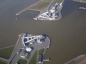
The northern and southern parts of the dam act like two giant bridges, providing access from the mainland to Kotlin Island and Kronstadt.
Historically, storm surges from the gulf have caused over 300 floods of varying severity within the city, some with devastating effects.
After a protracted halt in the 1990s and early 2000s, construction was resumed in 2005 due to the intervention of Russia's President Vladimir Putin, a native of Saint Petersburg.
The main benefit that most people cite[citation needed] is not flood control but rather improved traffic flow, as the dam completes the Saint Petersburg Ring Road.
[7] In the early literature, high winds from the Gulf of Finland were often cited as the cause of Neva flooding, but scientists now understand the more complex hydrometeorological chain of events behind it.
A low-pressure region in the North Atlantic moves onshore, giving rise to cyclonic lows on the Baltic Sea.
[10] For years, prominent scientists and statesmen of imperial Russia developed various plans for flood protection, and the Soviet Union implemented the idea.
Many options were considered before the Soviet government decided on a 25.4 km (15.8 mi) complex of 11 dams, including a six-lane highway on the top.
The measures being taken seem to be quite efficient – after the launch of the modern long-awaited South-West Wastewater Treatment Plant in 2006 the amount of biological and phosphate waste is expected to be lowered by 60% and 25%, respectively.