Saintes, Charente-Maritime
Saintes (French: [sɛ̃t] ⓘ; Poitevin-Saintongeais: Sénte) is a commune and historic town in western France, in the Charente-Maritime department of which it is a sub-prefecture, in Nouvelle-Aquitaine.
While a majority of the surrounding landscape consists of fertile, productive fields, a significant minority of the region remains forested, its natural state.
Following the French Revolution, it briefly became the prefecture of the department (then called Charente-Inférieure) during the territorial reorganization of 1790, until La Rochelle was designated and superseded it in 1810.
[9] Nearer to the river, the Cretaceous plateau gives way to more or less recent alluvial grasslands composed of bri, a type of clay.
The town is divided into 14 administrative areas : Les Boiffiers, Les Tourneurs, L'Ormeau de Pied, Recouvrance, La Fenêtre, Saint-Rémy, Saint-Vivien, Saint-Eutrope, Saint-Pierre, Saint-Pallais, Saint-Sébastien de Bouard, La Récluse, Le Maine-Saint-Sorlin and Bellevue.
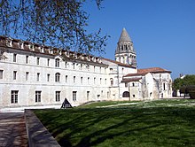
It possesses a significant number of historic monuments justifying its forming of the core of a conservation area that spans over 65 hectares (0.25 sq mi).
[12] Almost immediately west lies the neighbourhood of Saint-Eutrope, that has developed over the centuries around a rocky elevation bounded by two small valleys at right angles to the river.
The north of the urban area, the Saint-Vivien neighborhood has an old faubourg (exurb) inhabited since antiquity where the thermes de Saint-Saloine, ancient Roman baths are found.
Structured around the main access way of the Roman city, it was then linked to the town center by a bridge with a monumental entrance, the Arch of Germanicus.
During the Middle Ages, a funeral basilica, dedicated to the bishop Palladius, was established (and later replaced by the église Saint-Pallais, which gives its name to the neighborhood), then a Benedictine abbey of women amongst the largest in the region, the Abbaye aux Dames de Saintes.
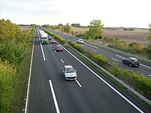
Saintes is a transportation hub of some importance, connected by two motorways and several secondary roads, national and departmental, that converge towards the rocade (partly a 2x2) that bypasses the city on its western and southern sides.
Saintes is on the Route Centre-Europe Atlantique, an expressway that links it to Limoges and Lyon in the east – its dualled western section Saintes-Saujon opened to traffic in 2008 making the two 25 minutes apart by car.
The Gare de Saintes (train station) is at the focal point of five railways that link the agglomeration to Nantes (by La Rochelle), Bordeaux, Angoulême, Niort and Royan; the trains are mainly part of the regional rail network TER Nouvelle-Aquitaine and the network Intercités.