Samaria (ancient city)
The local archeological site is jointly administered by Israel and the Palestinian Authority,[5] and is located on the hill's eastern slope.
[8] In earlier cuneiform inscriptions, Samaria is referred to as "Bet Ḥumri" ("the house of Omri"); but in those of Tiglath-Pileser III (ruled 745–727 BCE) and later it is called Samirin, after its Aramaic name,[9] Shamerayin.
This usage probably began after the city became Omri's capital, but is first documented only after its conquest by Sargon II of Assyria, who turned the kingdom into the province of Samerina.
[11] Samaria was situated north-west of Shechem, located close to a major road heading to the Sharon Plain on the coast and on another leading northward through the Jezreel Valley to Phoenicia.
[13] Archaeological evidence suggests a small rural settlement existed in Samaria during Iron Age I (11–10th centuries BCE); remains from this period are several rock-cut installations, several flimsy walls, and typical pottery forms.
[14] Remains from the early Iron Age II (IIA) are missing or unidentified; Franklin believes this phase consisted of merely an agricultural estate.
A later urban transformation of the capital and the kingdom, he believes, was characteristic of the more advanced phase of the Omride dynasty, probably occurring during the reign of Ahab (873–852 BCE).
[15] According to the Hebrew Bible, Omri, the king of the northern kingdom of Israel, purchased the hill from its owner, Shemer, for two talents of silver, and built on its broad summit a city he named Šōmrōn (Shomron; later it became 'Samaria' in Greek), the new city replacing Tirzah as the capital of his kingdom (1 Kings 16:24).
He, indeed, gave to the city which he had built the name of its former owner, but its especial connection with himself as its founder is proved by the designation which it seems Samaria bears in Assyrian inscriptions, "Beth-Khumri" ("the house or palace of Omri").
[24] According to Josephus, Herod rebuilt and expanded the city, bringing in 6,000 new inhabitants, and renamed it Sebastia (Hebrew: סבסטי) in the emperor's honor (translating the Latin epithet augustus to Greek sebastos, "venerable").
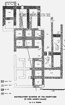
[23][25][better source needed] Samaria was first excavated by the Harvard Expedition, initially directed by Gottlieb Schumacher in 1908 and then by George Andrew Reisner in 1909 and 1910; with the assistance of architect C.S.
[33] Excavations in the palace uncovered 500 pieces of carved ivory, portraying exotic animals and plants, mythological creatures, and foreign deities, among other things.