San Diego Creek
San Diego Creek is a 16-mile (26 km) urban waterway flowing into Upper Newport Bay in Orange County, California, United States.
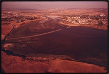
[2] From its headwaters in Laguna Woods the creek flows northwest to its confluence with Peters Canyon Wash, where it turns abruptly southwest towards the bay.
[5] San Diego Creek rises in the foothills of the Santa Ana Mountains in the residential communities of El Toro, and Lake Forest.
[6][7] The San Diego Creek drains a roughly rectangular shaped watershed of 112.2 square miles (291 km2) in central Orange County.
The watershed forms a flat, highly urbanized basin which is bounded on the north by the Loma Ridge, the "front range" of the Santa Ana Mountains, which separates it from the valley of Santiago Creek.
The primary urban land use in the San Diego Creek watershed (not including the rest of Newport Bay) is transportation and communications.
San Diego Creek did not have a well defined channel like it does today, but rather was a series of interconnected sumps and swamps in the lower elevations of the valley.
The Santa Ana River, the main waterway of Orange County, would sometimes flow into Newport Bay via what is now the lower part of the San Diego Creek channel.
[24] Lacking a direct outlet to the sea, the water table in the area was rather high and resulted in many year round artesian springs, which supported a rich variety of native plant and animal life.
[24] Starting about 2,000 years ago, the valley was inhabited by the Gabrielino (Tongva) Native Americans, who depended on the abundant game of the area for their sustenance.
A major landmark for the Gabrielino was the Red Hill, located in present-day Tustin at the northern tip of the Cienega de las Ranas.
[25] This has basis in historical events – every few decades, during an extremely wet winter, the Santa Ana River and Santiago Creek to the northwest would change their course and flood large portions of the coastal plain.
Shortly after California became part of the United States in 1850, a series of droughts and floods crippled the region, forcing Sepúlveda and other rancheros to sell their holdings.
[30] In 1932 the Irvine Conservation Dam, an earthen structure 27 feet (8.2 m) high, was built across San Diego Creek a mile (1.6 km) above the mouth, to capture storm runoff for irrigation, as well as provide flood protection to the salt works.
The construction of El Toro Marine Corps Air Station required the burial of a major tributary, the Agua Chinon Creek.
[24] The second was Marine Corps Air Station Tustin, an airship base, which was built over the deepest part of the Cienega de las Ranas.
A likely scenario is that the cannonball was lost by a contingent traveling to Riverside, and washed down the Santa Ana River (which during the 1860s still flowed into Newport Bay) by floods.
[34] Until the early 2000s, the area was heavily contaminated with the pesticides diazinon and chlorpyrifos, which were successfully removed from the creek after the Environmental Protection Agency implemented best management practices in the watershed.
[35] Currently the largest freshwater marsh in Orange County, the San Joaquin was once severely polluted and degraded, having been used first as the Newport salt works and then as farmland.
In 1972 the Irvine Company leased the marsh to hunting clubs, which restored the creek's original, longer course to the bay and built levees to create duck ponds.
[6] The creek also has a few tributaries that provide the outflow for several water supply and flood control reservoirs in the San Joaquin Hills and Santa Ana Mountains.