San Marino
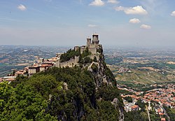
[9] Located on the northeastern side of the Apennine Mountains, it is the fifth-smallest country in the world,[10] with a land area of just over 61 km2 (23+1⁄2 sq mi) and a population of 33,642, as of 2023.
[11] San Marino is a landlocked country; however, its northeastern end is within ten kilometres (six miles) of the Adriatic coast through the Italian city of Rimini.
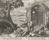
[14] According to legendary accounts that are first recorded centuries after he is suggested to have lived,[15][16] Saint Marinus left the island of Rab in present-day Croatia with his lifelong friend Leo, and went to the city of Rimini as a stonemason.
After the Diocletianic Persecution following his Christian sermons, he escaped to the nearby Monte Titano, where he built a small church and thus founded what is now the city and state of San Marino.
According to William Miller, these accounts of the origin of San Marino "are a mixture of fables and miracles, but perhaps contain some grains of fact".
[16] In 1291, San Marino appealed to the bishop of Arezzo, Ildebrandino Guidi di Romena, against the contribution demands by the Vicario del Montefeltro.
Jurist Palamede di Rimini decided in favour of San Marino and recognised its tax exemption from tributes demands of Montefeltro.
In 1296, when Guglielmo Durante was the governor of Romagna, Sammarinesi appealed to Pope Boniface VIII against the further requests by the Montefeltro podestas regarding tributes.
[18] In 1463, San Marino was enlarged by the inclusion of the communities of Faetano, Fiorentino, Montegiardino, and Serravalle; since then, the country's borders have remained unchanged.
[20] On 4 June 1543, Fabiano di Monte San Savino, nephew of the later Pope Julius III, attempted to conquer the republic, but his infantry and cavalry failed as they got lost in a dense fog, which the Sammarinesi attributed to Saint Quirinus, whose feast day it was.
Due to Onofri's intervention, Napoleon promised, in a letter to Gaspard Monge, scientist and commissary of the French Government for Science and Art, to guarantee and protect the independence of the Republic, even offering to extend its territory according to its needs.
[29] After the war, San Marino suffered from high rates of unemployment and inflation, leading to increased tension between the lower and middle classes.
[32] On 28 July 1943, three days after the fall of the Fascist regime in Italy, PFS rule collapsed and the new government declared neutrality in the conflict.
The Sammarinese government declared on the same day that no military installations or equipment were located on its territory, and that no belligerent forces had been allowed to enter.
San Marino has the political framework of a parliamentary representative democratic republic: the captains regent are heads of state,[43] and there is a pluriform multi-party system.
Different branches have varied functions, including performing ceremonial duties, patrolling borders, mounting guard at government buildings, and assisting police in major criminal cases.
Due to its striking blue, white, and gold uniform, it is perhaps the best-known part of the Sammarinese military, and appears on countless postcard views of the republic.
[citation needed] San Marino's postage stamps, which are valid for mail posted in the country, are mostly sold to philatelists and are a significant source of income.
The personal income tax (IGR, Italian: Imposta Generale sui Redditi) was introduced in 1984 and it was heavily reformed in 2013 with the goal of increasing fiscal revenue.
Although it is allowed to print its own postal stamps, San Marino is not allowed to coin its own currency and is obliged to use Italy's mint; the agreement does not affect the right of the Republic of San Marino to continue to issue gold coins denominated in Scudi[63] (the legal value of 1 gold Scudo is 37.50 euros).
[74] The Azienda Autonoma di Stato per i Servizi Pubblici, the Sammarinese state company for public transport, operates the country's bus network and aerial cablecar system.
[75][76] The main road is the San Marino Highway, a dual carriageway which runs between Borgo Maggiore and Dogana through Domagnano and Serravalle.
It serves Cerasolo, a frazione of Coriano, and the Rimini Sud exit of the A14 tolled highway, before terminating at the crossroads with the SS16 [it] state road.
[76] Start Romagna SpA operates several routes that run entirely in Italian territory but near the Sammarinese border, providing connections to Rimini, Verucchio, and Novafeltria.
[84] Running every fifteen minutes, the two-minute ride is renowned for its panoramic views over San Marino, the Province of Rimini, and the Adriatic Sea.
[100] The most significant bilateral agreement, ratified on 16 September 2013, provided San Marino a forty-year concession over some areas of Fellini Airport.
It is a small general aviation aerodrome in Torraccia, a village east of the castello of Domagnano, less than 200 metres (660 feet) from the Italian border.
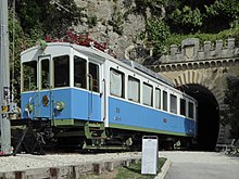
[114] Between 1932 and 1944, a 31.5-kilometre (19.6-mile) electrified narrow gauge railway operated between Rimini and the City of San Marino, serving Dogana, Serravalle, Domagnano, and Borgo Maggiore along its route.
[115] During the Second World War, the line was bombed and closed,[115][116] after which its tunnels sheltered refugees during the Battles of Rimini and San Marino.
Instead, it was held at the Autodromo Enzo e Dino Ferrari in the Italian town of Imola, about 100 km (60 mi) northwest of San Marino.