Santos Basin
The mobile salt of the Ariri Formation forms regional seals, as well as the shales of the post-salt sedimentary infill.
[3] Along the Brazilian coast, the basin is bounded by the Serra do Mar and stretches from Cabo Frio in the northeast to Florianópolis in the southwest.
The Outer High is likely a segmented series of rift fault-block shoulders which were uplifted and eroded during the Late Barremian.
[6] The Precambrian basement of the Santos Basin is exposed as the Araçuaí Belt along the Brazilian coast, most notably in the inselbergs of Rio de Janeiro, of which Sugarloaf Mountain is the most iconic.
The ancient rocks consist of a Neoproterozoic to Cambrian high-grade metamorphic core of granites and gneisses, formed during the collision of Gondwana in the Pan-African-Brasiliano orogeny.
[9] During the Early Cretaceous, the former continent Gondwana, as southern part of Pangea, starting to break-up, resulting in a sequence of rift basins bordering the present-day South Atlantic.
The Pelotas-Namibia spreading commenced in the Hauterivian, around 133 million years ago and reached the Santos Basin to the north in the Barremian.
The Late Aptian climate was arid with high evaporation rates which triggered hypersaline conditions in these marginal sag basins.
This resulted in the accumulation of thick layers of evaporites along the Brazilian and southwestern African continental margins, a process continuing towards the north later in the Cretaceous.
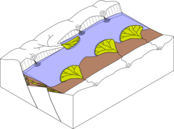
Differential thermal regimes and sediment loading of these units produced halokinesis; salt movement in the subsurface.
The resulting salt diapirs, listric and thrust faults and various salt-related structures produced several stratigraphic and combined stratigraphic-structural traps for hydrocarbon accumulation in the Brazilian and southwest African offshore.
[11] During the phases of halokinesis, dated to the Albian to Paleocene, several areas of the now deep water distal part of the Santos Basin were exposed to subaerial conditions and suffered erosion.
The distal parts of the basin were affected by E-W to NW-SE oriented shortening, sub-perpendicular to the Brazilian margin.
[13] The basement of the Santos Basin is composed of granites and gneisses of the Araçuarí Belt that formed at the western boundary of the Congo Craton.
The erosion resistant metamorphic and magmatic rocks are exposed in the Serra do Mar, forming the edge of the Santos Basin along the Brazilian coast.
[citation needed] The total stratigraphic thickness of the sediments in the Santos Basin has been estimated at 23,170 metres (76,020 ft) and has been described in detail by Clemente in 2013.
It also includes white, reddish lacustrine coquinas (shelly limestones) and sandstones, siltstones and shales of stevensite composition.
Similar to the Atafona Formation of the Campos Basin, the sandstones, stevensite-bearing siltstones and shales represent an alkaline lacustrine environment affected by volcanic activity.
Interbedded with the laminated microbialites there are limestones with packstone and grainstone textures made up of algal clasts and bioclasts (fragmented ostracods).
The sedimentary environment probably was restricted marine including mudflat sabkhas, evolving under an arid climate.
These clastic units are thought to represent alluvial environments distributed along the western Brazilian basin margin, along the Santos Hinge Line.
Facies analysis indicates a marine environment ranging from sub-littoral (inner neritic) and more rarely to pelagic (outer bathyal) conditions.
The sedimentary environment is thought to be transitional continental to marginal marine, ranging from alluvial to braided rivers and deltas.
Biostratigraphic data from palynomorphs, calcareous nannofossils and planktonic foraminifera indicate a Late Cretaceous age (Cenomanian-Maastrichtian).
[18] Itamambuca Group is 4,200 metres (13,800 ft) thick and includes four formations, Ponta Aguda, Marambaia, Iguape and Sepetiba.
[17] The Ponta Aguda Formation is up to 2,200 metres (7,200 ft) thick and consists of conglomerates, coarse to fine-grained sandstones interbedded with siltstones and shales.
[19] The Iguape Formation is 1,103 metres (3,619 ft) thick and consists of bioclastic calcarenites and calcirudites, containing bryozoa, echinoids, corals, foraminifera, fragmented shells, and algae remains.
The depositional environment is thought to be a marine carbonate platform, influenced by the arrival of alluvial clastics in the most proximal areas.
[19] The stratigraphy following the classifications by Vieira 2007, Kiang Chang 2008 and Contreras 2011 is: 4D Basin analysis of the Santos Basin has revealed insights about the interplay among the elements and processes of the petroleum system to assess source rock potential (vertical and horizontal distribution), thermal evolution of the source rocks, transformation ratio, hydrocarbon generation and charge, timing of migration, oil origin, quality, and volume of petroleum in the main reservoirs.
In terms of transformation ratio, the Barremian and Aptian source rock systems in the area reached 70% to 80% today where the main depocentres are.