Sara Sara
The volcano was worshipped by the local population, and an Inca mummy of a 15-year old girl was found on the summit by archaeologists.
[5] The town of Pausa lies 12 kilometres (7.5 mi) away from the volcano, and agriculture occurs in the valleys of the area.
[6] A disused road passes over the southern flank of the volcano and reaches an elevation of 4,600 metres (15,100 ft).
[12] Thick ash deposits underlie viscous lava flows that define the "Mollebamba Volcanics"[7] and reach lengths of 15 kilometres (9.3 mi).
[10] The CVZ features consists of two arcs of volcanoes on both sides of the Western Cordillera[27] and features composite volcanoes, lava domes and lava flows, of which El Misti, Huaynaputina, Sabancaya, Ticsani, Tutupaca, Ubinas and Yucamane have been active in historical times.
[29] The basement is formed by Precambrian and Paleozoic rocks, which are covered by Mesozoic and Cenozoic sediments and volcanites.
[37] Phenocrysts in the rocks include amphibole, biotite, hornblende, iron-titanium oxide, plagioclase, quartz, sanidine and sphene, and both their quantity and chemistry varied between various stages of activity.
Precipitation is seasonal and mostly falls during summer, at higher elevations in the form of hail and snow[42] which covers the ground for months.
There are no close weather stations, but above 4,500 metres (14,800 ft) elevation the climate is always cold with temperatures never rising above 5 °C (41 °F).
[43] Trees grow at lower elevations, while only ichu and quinua are present above 4,000 metres (13,000 ft).
[53][54] Future eruptions may endanger a population of 12,000[22]-8,000 around the volcano, which would be threatened by lahars, pyroclastic flows and tephra fallout.
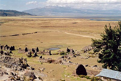
[3] Aside from Pausa, other towns and Lake Parinacochas (an important source of water for the region) are located close to the volcano.
[59] According to the writings of a cleric Cristóbal de Albornoz, who beginning in 1570 wrote about local religious practices, the local population considered Sara Sara a sacred mountain and offered gold, silver, animals and servants to it.
[62] The Yanapunku cave at 5,000 metres (16,000 ft) elevation features bones and ceramics from the Inca and Wari cultures.
Incaptiana is a site at the top of a hill at 4,565 metres (14,977 ft) elevation where Inca buildings were identified.