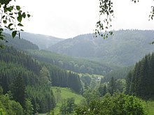
Sauerland
The Sauerland is the largest tourist region in North Rhine-Westphalia,[1] in particular for mountain biking and cycling, water sports and scenic recreation.
To the west the hills continue into the Bergisches Land, to the south into the Siegerland, and to the north-east into the Teutoburg Forest.
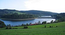
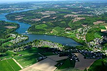
Several artificial lakes were created on the smaller rivers by building dams to store water for the nearby Ruhr area, the biggest reservoirs being the Möhne and Bigge.
Although the highest elevation of the Sauerland is the Langenberg (843 m) near Olsberg, the much more renowned summit, which is well known for the nearby skiing facilities, its weather station and observation tower, is the slightly lower Kahler Asten (842 m) near Winterberg.
The Rheinisches Schiefergebirge was subjected to folding and faulting in the Variscan orogeny in Carboniferous times and eroded to a peneplain in the Permian.
The tectonic uplift to the present-day low mountain range began approximately 500,000 years ago and is still going on.
[3] Most of the bedrock underneath the Sauerland originates from a Middle and Upper Devonian period, when it was under a marginal and shallow sea.
In some areas of the Sauerland the occurrence of lead-zinc-silver-ores lead to the development of a considerable mining industry, the center of which was the town of Meggen.
The sandstones, greywackes and quartzites of the Sauerland as well as, to a minor extent, the limestones are still exploited in numerous quarries.
In addition, massive outbreaks of bark beetles have been killing up to 60 % by area of forest in some regions of the Sauerland.
In the region, railways were once the most important means of transportation, but between 1950 and 1990 many smaller branch lines were closed and rail travel is now only present in the major valleys.