Land Ordinance of 1785
The Ordinance set up a survey system that eventually covered over three-quarters of the area of the continental United States.
[1] The earlier Land Ordinance of 1784 was a resolution written by Thomas Jefferson calling for Congress to take action.
The Confederation Congress appointed a committee consisting of the following men: On May 7, 1784, the people reported "An ordinance for ascertaining the mode of locating and disposing of lands in the western territories, and for other purposes therein mentioned."
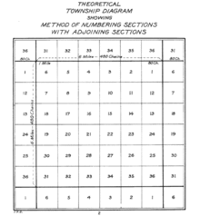
It required surveyors "to divide the said territory into townships seven miles square, by lines running due north and south, and others crossing these at right angles.
[8][12] Howe and others give Thomas Hutchins credit for conceiving the rectangular system of lots of one square mile in 1764 while a captain in the Sixtieth, or, Royal American, Regiment, and engineer to the expedition under Col. Henry Bouquet to the forks of the Muskingum, in what is now Coshocton County, Ohio.
The various states and counties ignored, altered or amended this provision in their own ways, but the general (intended) effect was a guarantee that local schools would have an income and that the community schoolhouses would be centrally located for all children.
"[19] Knepper notes: "Sections number 8, 11, 26, and 29 in every township were reserved for future sale by the federal government when, it was hoped, they would bring higher prices because of developed land around them.
Congress also reserved one third part of all gold, silver, lead, and copper mines to its own use, a bit of wishful thinking as regards Ohio lands.
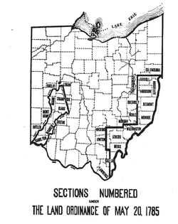
This was not possible, as the area next to Lake Erie was property of Connecticut, so the Canadians had to wait until the establishment of the Refugee Tract in 1798.
[25] The surveyed townships of the Land Ordinance of 1785, writes historian Jonathan Hughes, "represented an amalgam of the colonial experience and ideals.
In colonial times, New England settlements contained dedicated public space for schools and churches, which often held a central role in the community.
The clause in the Land Ordinance of 1785 which dedicated "Lot Number 16" of each western township for public education reflected this regional New England experience.
The Southern land system, marked by individualism and personal initiative, also helped shape the ordinance.
This system encouraged individuals to amass large plantations instead of settling into dense communal development.
[30] Perhaps the committee's resistance against indiscriminate location and support for limited and disciplined land settlement was an implicit attempt to create a structural barrier to developing a plantation economy that was dependent on slave labor.
The committee could have been attempting to effectively eradicate slavery in the West after Jefferson failed to outlaw it in the Land Ordinance of 1784.
The Northwest Ordinance of 1787 stated, "Religion, morality, and knowledge being necessary to good government and the happiness of mankind, schools and the means of education shall forever be encouraged.
Once the land was dedicated, the actual development of the public schools was the responsibility of the local township or the particular state.
[32] Although the great Ordinances of the 1780s set the framework for a national system of schools by dedicating land across the West, the devolved development and administration by the state and local government led to unique results.
Aside from raising funds for a financially struggling government, the westward expansion outlined in the Land Ordinances of the 1780s also provided a framework for spreading democratic ideals.
[29] The systematic and highly organized westward settlements, with their local governments and central square dedicated towards public education, were a concerted effort to inspire civic duty and participation in the democratic process.
Usher relates this initiative to "the Supreme Court in Cooper v. Roberts (1855), 'plant in the heart of every community the same sentiments of grateful reverence for the wisdom, forecast, and magnanimous statesmanship of those who framed the institutions of these new States.