Schuylkill Canal
At the time, the Schuylkill River was the least expensive and most efficient method of transporting bulk cargo, and cities on the U.S. East Coast were experiencing an energy crisis.
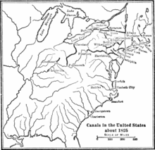
These represented the growing impetus in the United States to develop a water transportation network similar to that emerging in Great Britain.
[7] These and regularly increasing tonnages shipped down to Philadelphia's docks over the next 2–3 years attracted investors and speculators from all along the Eastern Seaboard to capitalize and fund similar companies.
Even as late as the year 1812, when it was sought to secure an act authorizing the improvement of the Schuylkill river in order to convey coal to Philadelphia, the representative of Schuylkill County in the state senate declared there was no coal in his district; that there was a kind of black stone that was called coal, but that it would not burn!As related in The Delaware and Lehigh Canals history, two of the principle investors in the Schuylkill Navigation Company were partner industrialists and mill owners White and Hazard, who were anxious to secure a reliable source of fuel for their mills.
Early on in the board meetings of the new corporation they'd quarreled with others over the funding, timings, and tasks necessary and when they could not prevail to speed the project, immediately explored the option of making a navigation on the Lehigh River and acquiring the mining rights[a] of the failing Lehigh Coal Mine Company and other investors to fund the projects.
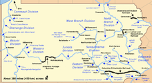
The initial configuration completed in 1827, was waterway of 108 miles (174 km) was linking Philadelphia to Port Carbon in the Southern Anthracite Coal Fields near Pottsville.
[8][9] By the early 1820s, the coal coming down the Lehigh and Schuylkill canals having alleviated the high costs of heating, overcoming in just a few years the long suffered shortages of fuels in Eastern cities and towns[c] The Auburn Tunnel, a 450-foot (137 m) bore through a hill near Auburn, was completed in 1821, but by 1857, due to increased traffic, canal capacity (widening) modifications turned it into an open-cut.
[13] By transporting bulk cargoes and provide water power, the Schuylkill Navigation transformed the towns of Reading, Norristown, and Pottsville into early manufacturing centers.
In response, the Schuylkill Navigation Company enlarged its canals; by 1847, they could accommodate the passage of boats carrying 230 tons of coal.
These barges were better than twice the size that could be used on the rival Lehigh and Delaware Canals with the latter's limited lock lengths;[9] an artifact of having a state run a practical construction project without businessmen’s balancing viewpoints.
Railroads could reach mine heads and coal breakers where no stream existed to support the costly digging of a new ditch.
In 1870, its board of directors forced by stockholders, the Schuylkill Navigation Company leased its waterway to the Philadelphia and Reading Railroad for 999 years, surrendering to the competition.
Under the railroad's control, the Schuylkill Navigation continued to decline as a general freight carrier, but operated primarily as a coal road, like the Lehigh and Delaware Canals into the 1930s, since for heating and especially, steam power, nearly everyone needed anthracite.
While the Chester County Canal was initially built to provide water power to the mill, in 1847 it carried scheduled passenger service between Phoenixville and Norristown.
An impounding basin from the silt removal project cuts the canal after Longford Road and the final mile of the Reach, has been filled in.
On December 30, 2017 what is thought to be the non-mechanized, human powered speed record was set on the Oakes Reach by Todd Martin, originally of Mont Clare.
This length of the Trail makes use of the general course of the filled portion of the Oakes Reach and originally used the old canal aqueduct to cross Crossman's Run.
On 14 February 2008, a meeting was held to announce the survey work for the extension of the Schuylkill River Trail along the towpath of the watered portion of the Oakes Reach.
However, this one-mile-long segment of Schuylkill River Trail is a narrow crushed-stone path, designed for pedestrians and slower bicycles.
Cyclists who prefer higher speeds are encouraged to ride on parallel Walnut Street, rather than the Longford Road-to-Mont Clare section of tow-path.