Isles of Scilly
Historically, the Isles of Scilly were known in Latin as Insulae Sillinae,[8] Silina or Siluruni,[9] corresponding to Greek forms Σίλυρες and Σύρινες.
Later, c. 570, when the modern Midlands—and, in 577, the Severn Valley—fell to Anglo-Saxon control, the remaining Britons were split into three separate regions: the West (Cornwall), Wales and Cumbria–Ystrad Clyd (Strathclyde).
[citation needed] In Snorri Sturluson's Royal Sagas of Norway, it is stated that this seer told him: Thou wilt become a renowned king, and do celebrated deeds.
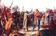
They went first to the Suðreyar [Hebrides], and all along the west to the Syllingar, where they gained a great victory in Maríuhöfn on Columba's-mass [9 June], and took much booty.
[citation needed] It is generally considered that Cornwall, and possibly the Isles of Scilly, came under the dominion of the English Crown for a period until the Norman conquest, late in the reign of Æthelstan (r. 924–939).
[31] At the turn of the 14th century, the Abbot and convent of Tavistock Abbey petitioned the king, stat[ing] that they hold certain isles in the sea between Cornwall and Ireland, of which the largest is called Scilly, to which ships come passing between France, Normandy, Spain, Bayonne, Gascony, Scotland, Ireland, Wales and Cornwall: and, because they feel that in the event of a war breaking out between the kings of England and France, or between any of the other places mentioned, they would not have enough power to do justice to these sailors, they ask that they might exchange these islands for lands in Devon, saving the churches on the islands appropriated to them.
[32]William le Poer, coroner of Scilly, is recorded in 1305 as being worried about the extent of wrecking in the islands, and sending a petition to the King.
By 1651 the Royalist governor, Sir John Grenville, was using the islands as a base for privateering raids on Commonwealth and Dutch shipping.
[33] During the night of 22 October 1707, the isles were the scene of one of the worst maritime disasters in British history, when out of a fleet of 21 Royal Navy ships headed from Gibraltar to Portsmouth, six were driven onto the cliffs.
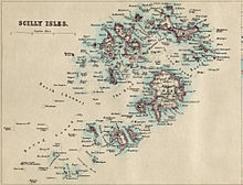
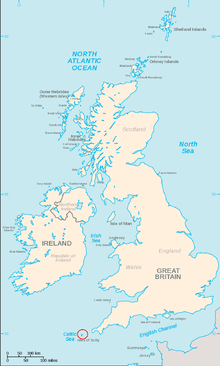
[34] The Isles of Scilly form an archipelago of five inhabited islands (six if Gugh is counted separately from St Agnes) and numerous other small rocky islets (around 140 in total) lying 45 kilometres (24+1⁄2 nautical miles) off Land's End.
[37] As part of a 2002 marketing campaign, the plant conservation charity Plantlife chose sea thrift (Armeria maritima) as the "county flower" of the islands.
The Isles of Scilly are the only British habitat of the lesser white-toothed shrew (Crocidura suaveolens), where it is known locally as a "teak" or "teke".
Many of the northern islands can be reached from Tresco, including Bryher, Samson and St Martin's (requires very low tides).
Although the sound between St Mary's and Tresco, The Road, is fairly shallow, it never becomes totally dry, but according to some sources it should be possible to wade at extreme low tides.
All the islands of Scilly are all composed of granite rock of Early Permian age, an exposed part of the Cornubian batholith.
Scilly is situated far into the Atlantic Ocean, so many North American vagrant birds will make first European landfall in the archipelago.
The Godolphins and their Osborne relatives held this position until 1831, when George Osbourne, 6th Duke of Leeds surrendered the lease to the islands, with them then returning to direct rule from the Duchy of Cornwall.
Accordingly, in 1890 the Isles of Scilly Rural District Council (the RDC) was formed as a sui generis unitary authority, outside the administrative county of Cornwall.
Section 265 of the Local Government Act 1972 allowed for the continued existence of the RDC, but renamed as the Council of the Isles of Scilly.
As of 2015[update], 130 people are employed full-time by the council[65] to provide local services (including water supply and air traffic control).
Over the years the nature of this trade has varied, due to wider economic and political factors that have seen the rise and fall of industries, such as kelp harvesting, pilotage, smuggling, fishing, shipbuilding and, latterly flower farming.
In a 1987 study of the Scillonian economy, Neate found that many farms on the islands were struggling to remain profitable due to increasing costs and strong competition from overseas producers, with resulting diversification into tourism.
[84] Tourism is also a highly seasonal industry owing to its reliance on outdoor recreation, and the lower number of tourists in winter results in a significant constriction of the islands' commercial activities.
[citation needed] Because of its position, Scilly is the first landing for many migrant birds, including extreme rarities from North America and Siberia.
[84] Businesses dependent on tourism, with the exception of a few hotels, tend to be small enterprises typically employing fewer than four people; many of these are family run, suggesting an entrepreneurial culture among the local population.
[84] However, much of the work generated by this, with the exception of management, is low skilled and thus poorly paid, especially for those involved in cleaning, catering and retail.
Due to a lack of local casual labour at peak holiday times, many of the larger employers accommodate guest workers.
[98] A majority of the freehold land of the islands is the property of the Duchy of Cornwall, with a few exceptions, including much of Hugh Town on St Mary's, which was sold to the inhabitants in 1949.
[101] Housing demand outstrips supply, a problem compounded by restrictions on further development designed to protect the islands' unique environment and prevent the infrastructural carrying capacity from being exceeded.
This has pushed up the prices of the few private properties that become available and, significantly for the majority of the islands' populations, it has also affected the rental sector where rates have likewise drastically increased.