Scotts Bluff National Monument
Scotts Bluff National Monument is located west of the City of Gering in western Nebraska, United States.
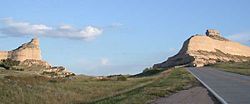
This National Park Service site protects over 3,000 acres of historic overland trail remnants, mixed-grass prairie, rugged badlands, towering bluffs and riparian area along the North Platte River.
The expedition party noted the bluffs as the first large rock formations along the North Platte River where the Great Plains started giving way to the foothills of the Rocky Mountains.
Beginning in 1841, multitudes of settlers passed by Scotts Bluff on their way west along the Great Platte River Road to Oregon, and later California and Utah.
[10] Many emigrants preferred this route rather than trying to traverse the badlands on the north side of the bluffs or detouring south to the older trail at Robidoux Pass.
Once permanent settlements had been established nearby, residents and travelers went to the bluff as a destination because of its extensive views of the flat land stretching to the east, the hills and mountains to the west, and the river valley in between.
Exhibits focus on the westward expansion and pioneers, the drawings and paintings of William Henry Jackson, and the geology and paleontology of the region.
In the 1930s, a roadway leading to the top of Scotts Bluff was constructed by the Civilian Conservation Corps, organized by President Franklin D. Roosevelt's administration.
According to Washington Irving, around 1825 a fur trapping party was “descending the upper part of the (Nebraska) River in canoes when their frail barks were overturned and all their powder spoiled.
After suffering extremely from hunger, they arrived at Laramie’s Fork, a small tributary of the north branch of the Nebraska, about sixty miles above the cliffs just mentioned.
While they were searching round in quest of edible roots they discovered a fresh trail of white men, who had evidently but recently preceded them.
“On the ensuing summer, these very individuals, visiting these parts in company with others, came suddenly upon the bleached bones and grinning skull of a human skeleton, which by certain signs, they recognized for the remains of Scott.
This was sixty long miles from the place where they had abandoned him; and it appeared that the wretched man had crawled that immense distance before death put an end to his miseries.
The wild and picturesque bluffs in the neighborhood of his lonely grave have ever since borne his name.”[13]Another version of the legend portrays Scott's companions in more favorable terms: A melancholy tradition accounts for the name of this spot.
Another early military map of Nebraska and the Dakotas published in 1875 by G.K. Warren dropped the apostrophe and labeled the feature simply as Scotts Bluff.
These formations include the caprock, composed of hard, lime-cemented ledges called “pipy” concretions formed when calcium carbonate (lime) precipitated from groundwater.
[20] During World War II, the United States built hundreds of T2 oil tanker ships and named many of them after national monuments.