Seefeld Saddle
To the south the terrain descends via the Zirler Berg down to the Inn valley, to the north of the plateau lie the Wetterstein Mountains (max.
Whilst the water of the Mühlbach northeast of Auland drains through the Niederbach southwards into the Danube tributary of the Inn, the waters of the Raabach and Haglbach flow through the Seebach (draining the Wildsee) as the Drahnbach and Gießenbach northeast into the Danube tributary, the Isar.
It approaches from the southeast from Zirl in the Inn valley (with a junction at Innsbruck with the A12 or B 171) over the south and east flanks of the Zirler Berg (with a gradient of up to 16%) through Reith and Seefeld and then heads northeast to the village of Scharnitz on the River Isar by the Austro-German border, crossing the Scharnitz Pass, from where it continues in Germany as the B 2 running past Mittenwald via Garmisch-Partenkirchen as far as Gartz (Oder).
In the area of the eastern bypass around Seefeld the road reaches a height of more than 1,220 m north of the saddle near the junction of Seefeld-Mitte.
The Isar valley narrows as a result of the foothills of the Arnspitze Group near Scharnitz and gives travellers the impression of a gate (Lat.

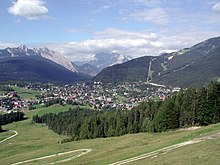
the Seefeld Saddle is on the right behind the trees