Darnestown, Maryland
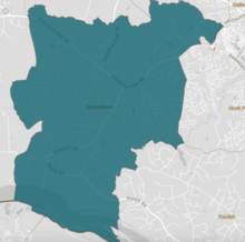
Darnestown is a United States census-designated place (CDP) and an unincorporated area in Montgomery County, Maryland.
The name Darnestown comes from William Darne, who owned the most land in the area at the beginning of the 19th century when the community post office opened.
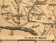
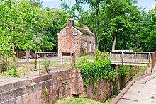
The community thrived in the 19th century during the golden years of the Chesapeake and Ohio Canal, as the improved transportation facilities offered area farmers access to more markets.
The first European (mostly Scottish and English) settlements in what would become Montgomery County, Maryland, were established in 1688, near Rock Creek and what was to become Rockville.
[5] His daughter Ruth Beall married Charles Gassaway, who built a brick home named Pleasant Hills around 1765.
Darne was a civic leader who served in the Maryland House of Delegates, as a judge, and as director of the Chesapeake and Ohio Canal.
[21] At the beginning of the American Civil War, Union Army leadership realized that the Potomac River area near Seneca was a possible crossing point for a Confederate invasion that could include Washington.
About halfway between the canal and Darnestown, Major General Nathaniel P. Banks kept his headquarters at the Samuel Thomas Magruder farm where the Potomac River could be observed from high ground.
[22] Troops from the 13th Massachusetts Infantry Regiment occupied the Pleasant Hills home originally built by the Gassaways.
[26] These factors limited growth for Darnestown, as nearby communities on the new rail line had "unprecedented facilities" for "personal travel and transportation of productions and supplies".
[Note 4] Darnestown grew very little until the 1960s, when wealthy families began buying farmland for living quarters and horseback riding.
The church's cemetery contains the graves of some of the area's early settlers, including members of the Darne, Clagett, Offutt and Tschiffely families; Chesapeake and Ohio Canal lock keepers Pennifield, Violette, and Riley; and philanthropist Andrew Small.
[35] Additional historic places include Black Rock Mill, located in Seneca Creek State Park.
[38][39] The Samuel Thomas Magruder farmhouse, now privately owned, was headquarters for Major General Nathaniel P. Banks in 1861 during the American Civil War.
[40][41][22] After Magruder and his wife died in the 1880s, the farm became the home of their daughter Mary and husband Wilson B. Tschiffely, who purchased the Seneca Mill in 1902.
However, in 1878 the U.S. Census Bureau created a new Minor Civil Division (MCD) named Darnestown District (No.
[50] The CDP uses the Muddy Branch, Turkey Foot Road, and Jones Lane for most of its eastern border instead of rivers further east.
[60] An 1879 history of Montgomery County describes the Darnestown village as having a population of 200 with a church, academy, public school, postmaster, two merchants, two millers, and 16 farmers.
[71] As of 2018 estimates by the U.S. Census Bureau, Darnestown has a median household income of $227,962 and a poverty rate of 0.3 percent.
The Darnestown Civic Association is a volunteer organization that participates in numerous issues affecting the area and publishes a quarterly newsletter.
[75] The data based on the Census Bureau 2012 Survey of Business Owners lists 881 firms in Darnestown.
[76] Darnestown is close to major employers such as Shady Grove Hospital and the technology companies along Interstate 270.
[78] Darnestown residents who commute further distances to work typically use Interstate 270 or River Road to the Capital Beltway.
[50] Maryland Route 28, a state highway, connects Darnestown with Rockville and provides access to Interstate 270.
[88] Curbside garbage, recycling, and yard waste collection and disposal are not provided by the county, and independent contractors must be used.
[89] The Washington Suburban Sanitary Commission (WSSC) provides water and wastewater treatment for Darnestown.
[90] Drinking water comes from the WSSC treatment facility on the Potomac River, while sewage is treated at a plant in the District of Columbia.
[94] MedStar Health Urgent Care in Gaithersburg is located in The Shops at Potomac Valley on Darnestown Road near Quince Orchard High School.
[124] Seneca Creek State Park is an irregular-shaped park of 6,300 acres (2,500 ha) that follows Seneca Creek for 14 miles (23 km) from beyond Clopper Lake (northern part of Darnestown CDP) to the Potomac River (southern part of Darnestown CDP).
[141][142] The Maryland SoccerPlex is located less than 5 miles (8.0 km) from the Darnestown village and has indoor and outdoor facilities for soccer and other activities.