Sengsengebirge mountains
The heavily karstified mountain range consists mainly of Wetterstein limestone, drains mostly underground and is criss-crossed by several large caves, including the Klarahöhle with a length of over 31 kilometers.
The name can be traced back to the extensive use of its forests in the Middle Ages by scythe forges, of which only a few remain today.
The Sengsengebirge was developed for tourism at the beginning of the 20th century and offers a variety of opportunities for hiking, snowshoe and ski tours and some climbing routes.
South of the confluence of the Hinterer Rettenbach with the Teichl to the Haslersgatter 1,154 m above sea level (AA) is the Windischgarstner Becken.
The lower limit of the karren and doline phenomenon can generally be given as around 1200 m.[2] Tectonics, the Sengsengebirge is a mighty, northward tilted (north-vergent) anticline of the Staufen-Höllengebirgs-Decke, which belongs to the Tyrolean cover unit (Tyrolian), whereby in the south the Hangendschenkel rises at an angle of between 30 and 40 degrees and gradually turns into a saigere to slightly overturned layer position up to the northern edge of the Sengsengebirgs.
[3] In its central part, the Höllengebirgsdecke consists almost exclusively of Wetterstein limestone, which was built up from the Anisian to the early Carnian of the Triassic around 247 to 235 million years ago.
[3] The Sengsengebirge was partly glacierized during the Ice Ages, whereby the plateau around the Hoher Nock was ice-free and the Neogenee old landscape was preserved.
It is assumed that during the High Glacial this "Sengsengebirgs glacier" extended in a western section at least as far as the valley floor of Hopfing.
The moraine remains in the Hochkar below the Hoher Nock belong to an eastern section that flowed eastwards into the Blöttenbach valley.
A small local glacier may have formed on the south side, which originated under the Schneeberg near the Hoher Nock, flowed in the cirque to the Koppenalm and further on via the Budergrabenkar towards the Rettenbach.
[5] The Wetterstein limestone, which is easy to karstify, offers favorable conditions for cave formation in combination with the remaining interface structure.
Due to the frequent accumulation of clouds on the northern edge of the Limestone Alps, there is an above-average amount of snowfall for the altitude in the area of the main ridge above the Hopfingboden.
On the other hand, it climbs up to the summit region of the Hoher Nock, leaving only extreme rock and wind zones free.
[11] Alpine meadows form on wind-exposed and partially blown-off sites in winter, in which especially the Horst sedge (Carex sempervirens) and the calcareous bluegrass (Sesleria varia) dominate.
[15] The cave ground beetle Arctaphaenops muellneri, an endemic species of the Sengsen and Reichraminger Hintergebirge, has been found in the Rettenbachhöhle and the Klarahöhle.
[19] A number of scythe factories (guild in Kirchdorf an der Krems) were established in the area, of which only very few have survived today.
In a letter of bequest from 1748, Franz Anton von Lamberg gave the master scythe smith on the Rossleithen, Wolf Leopold Schreckenfux, a woodland on the "inner Grestenberg and Steyreck" for use.
The legal dispute over the Restitution Claim of Count Lamberg was ended in 1961 with a settlement and the payment of 800,000 Schilling to his heir.
Field names such as Haidenalm and Kühböden indicate that they were more widespread at the time, and numerous foundation walls of ruined huts are reminders of this.
These numbers were generally reduced during the regulations in 1862 and in 1882 grazing rights for at least 108 horned cattle, 90 sheep and 70 goats were replaced.
Due to the number of livestock being too high for the natural balance, the alpine pastures showed signs of degeneration, including karstification.
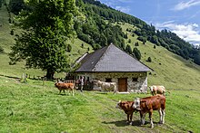
[28] The large alpine pastures still in use today (2023) include the Feichtaualm and the Blumauer Alm in the northern Sengsengebirge and the Rumpelmayr Reit at the eastern end of the mountain range.
This trail bears the number 469 and leads over the peaks Schillereck, Hochsengs, Gamskogel, Rohrauer Größtenberg and Hoher Nock, where it reaches its highest point.
Well-known ski tours that are marked on the maps include:[33] In contrast to other more spectacular mountain groups, the technical climbing development only began late, around 1910.
Franz Tham and Adam Döppl in particular achieved difficult first ascents on the north side of the Hoher Nock during this time.
Today, there are several climbing routes on the Nockpfeiler in the north and on the Nockplatte in the south up to Difficulty level V.[34] In 1976, the central parts around the narrower karst massif covering 3400 hectares were designated as the Sengsengebirge Nature Reserve, which was incorporated in its entirety into the Kalkalpen National Park in 1997.
Today, with the exception of the southern and western edges, the entire mountain range is part of the protected area.
The clearing island of Rießriegl above the Hinteres Rettenbachtal valley is permanently inhabited and is excluded from the national park area.
[35] The main ridge of the Sengsen Mountains is depicted on the 50 euro gold coin "In the Deepest Forest" from the "Natural Treasure Alps" series.
According to another tale, the milk buckets are said to come to light in the Wunderloch, a small pond near Molln, which is said to be immeasurably deep.