Sétif
It is an inner city, situated in the eastern side of Algeria, 270 kilometers east of Algiers, 131 km west of Constantine, in the Hautes Plaines region south of Béjaia and Jijel.
The prehistoric site of Ain El Ahnech is located a few kilometers east of the city, and the age of the lithic remains is estimated by archaeomagnetism to be about 2.4 million years old.
[7] On the northwest edge of the town two great Christian basilicas were built at the end of the fourth century, decorated, again, with splendid mosaics,[8] and a Bishopric was founded at this time.
We know little of the early Islamic town, but by the tenth century the area outside of the fortress was once more filled with houses: on the site of the Roman baths over twelve of these were excavated, with large courtyards surrounded by long, thin, rooms.
The city was successively administered by the Muslim dynasties that ruled North Africa: Umayyads, Abbasids, Aghlabids, Fatimids, Zirids, Almohads, Hafsids, Ottomans.
According to Khelifa Abderrahmane, the results of these excavations are very interesting: "The city was not totally abandoned and the remains of the baths served as occasional shelter for men and livestock.
According to Khelifa Abderahmane, the important thing is that the excavation was able to identify a typology of the tenth and eleventh century habitat for this region, with pieces that are longer than they are wide.19 The Arab tribe of Bani Hil'izz was the first to be found in the area.
On 8 May 1945, the day of the formal end of World War II in Europe, Sétif was the starting point for a series of nationalist riots that were bloodily suppressed by the French colonial authorities.
The demonstrations and the explosion of violence that accompanied them originated in a nationalist insurrection project whose aim was to create a "liberated zone" with a provisional government led by Messali Hadj.
The Sétif riot, often presented as the consequence of popular anger caused by the death of the flag-bearer Bouzid Saâl [fr], was in fact "a real armed insurrection that left 23 dead and 80 wounded Europeans and estimates of Algerian casualties vary widely from 2,000 to 40,000.
These rock formations are rich in mineral resources, including iron, lead, and zinc, which have played a significant role in the economic development of the region.
The diverse and varied landscape provides a rich and interesting environment, with features such as towering cliffs, rolling hills, and fertile valleys all contributing to the character of the region.
They are located in narrow areas to the north of the city Cambrian and Mastricht formations: Represents white clay with fragments of sandstone and black shale.
This geographical diversity reflects the historical, cultural and economic richness of the city of Setif and its surrounding areas, making it a unique destination for geological tourism.
On the other hand, the high percentage of forested area within the wilaya provides important ecological benefits, including carbon sequestration, wildlife habitat, and recreation opportunities.
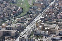
Setif saw a significant growth in modern architecture between 1930 and 1962, reflecting the urban dynamics of the city and being influenced by various factors such as financial measures, technological processes, and the work of architects and contractors.
The city center of Setif was reinvested twice, with modern architecture being promoted in the 1930s with public operations, and after World War 2 by the holders of agricultural capital, who consolidated the best locations to form tall buildings made with reinforced concrete structures.
The architecture in The Pines was utilitarian, focusing on functionality and the absence of ornament, while the Bouaroua district located at the eastern end of the city saw a similar situation.
The wali of Sétif has recently expressed his commitment to improving the city's image and has taken steps to work with local authorities and the Department of the Environment to address any issues related to cleanliness and public health.
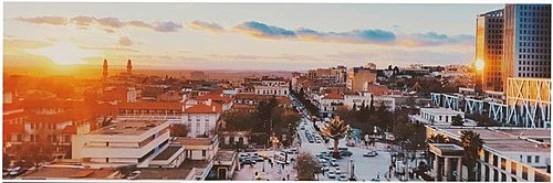
[24] Despite the fact that the city has experienced rapid growth in recent years, it has managed to maintain its unique cultural identity and continues to attract people from all over the country.
Adviser to the President of the Republic for the economy, Abdelaziz Khellaf, has praised the wilaya of Sétif as one of the most important poles of industry in the country, thanks to the efforts and determination of its economic operators.
The director of industry and mines, Mermouchi Mohamed, also believes that the wilaya of Sétif is poised for a prosperous future in terms of investment, wealth creation, and job growth.
Cattle breeding is highly developed in the most favorable suburban areas where irrigated forage crops or grasslands along the streams that run through the city from north to south are observed.
This fountain represents a huge sculpture created by the French sculptor Francis de Saint-Vidal, the stories differed on the true history of the construction of this monument.
The citadel is built from massive blocks of cut stone, 2.5 meters thick, in a rectangular shape.Park Mall Setif is a shopping mal that has been open since February 2016.
The Mferemsa dish is also typical of the city, large sheets of dough, cooked and drizzled with a sweet, salty, sour and spicy red sauce, made up of onions, spices, tomatoes, chickpeas, apricots, and raisins, all accompanied by meat.
The art of jewelry making is one of the oldest traditional manual trades in Sétif, it is primarily based on gold and silver plates to produce items such as Esskhab, El-Mhezma, El-Mekkies, El-Djerrar, El-Khelkhal, etc....
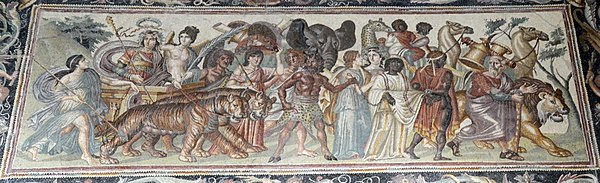
The second stopover presents the Roman and Byzantine civilization which left many traces in Sétif, such as collections of ceramics, glass, funerary steles and especially mosaics including that of Venus or that of Bacchus.
Hammadid art is represented by ceramic fragments with epigraphic decoration; geometric and floral: the carved plaster columns and capitals are painted in green and red colors.
Setif has a football club, the Entente Sportive de Sétif (ESS) founded in total discretion in September 1958, on the orders of the command of the FLN revolution, for a mission of Fidaye.