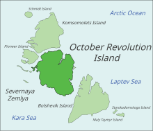
Severnaya Zemlya
Until recently, ice joined the islands to Eurasia, even at its smallest extent during the late summer melt season, blocking the Northeast Passage between the Atlantic and the Pacific.
[5] However, Hovgaard was prevented from accomplishing his objectives after having become trapped in thick ice, and his expedition was unable to reach even the shores of the Taymyr Peninsula.
The chief organiser and first captain of the Vaygach was officer Aleksandr Vasiliyevich Kolchak of the Imperial Russian Navy.
The expedition, privately financed, was launched in 1910 and led by Boris Vilkitsky on behalf of the Russian Hydrographic Service.
[7][8] This venture accomplished its goal of exploring the uncharted areas of the continental side of the Northern Sea Route.
On 3 September 1913 (22 August 1913 in the Julian calendar used by Russia at the time), members of Vilkitsky's expedition landed on what is now known as Cape Berg on present-day October Revolution Island.
[12] In May 1928, Umberto Nobile and his crew in the Airship Italia attempted to overfly the islands, but adverse weather conditions forced them to turn southward when only an hour or two from viewing the archipelago's coastline.
[13] In the spring of 1931, Georgy Ushakov, accompanied by the geologist Nikolay Urvantsev, the veteran surveyor Sergei Zhuravlev, and the radio-operator Vasily Khodov, thoroughly surveyed Severnaya Zemlya during a two-year expedition to the archipelago.
[15] The first detailed map drawn by the expedition's cartographers showed Severnaya Zemlya divided into four main islands.
With reference to Severnaya Zemlya Ushakov wrote: I have seen God-forsaken Chukotka Peninsula, blizzard-ridden Wrangel Island, twice visited fog-enshrouded Novaya Zemlya, and I have seen Franz Josef Land with its enamel sky and proud cliffs garbed in blue, hardened glacial streams, but nowhere did I witness such grimness or such depressing, lifeless relief...[16]The Graf Zeppelin flew over the area during its polar flight of July 1931 and recorded some cartographic and meteorological data; Hugo Eckener tried to take pictures of the yet unsurveyed western coast, but it was obscured by fog and clouds.
[17] Although German communists had endured suffering under the Third Reich, due to anti-German sentiment caused by the 1941–1945 German-Soviet War in the USSR some features of Severnaya Zemlya that had been previously named in solidarity with German Communism were given Russian or neutral-sounding names, e.g. Cape Unslicht becoming Mys Peschanyy and Proliv Yungshturm becoming Yuny Strait.
[18][19][20][21] During the period of the Cold War (1940s to 1980s), the islands of Severnaya Zemlya continued to be studied by a team of geologists from NIIGA (the Scientific Research Institute of Arctic Geology) in St. Petersburg, (then known as Leningrad).
The glacierised area on Bolshevik, the southernmost main island of the group, covers about a quarter of its land's surface.
[25] This archipelago encloses the northern limits of the Kara Sea on its western shores, together with Novaya Zemlya, located roughly 1,000 km (620 mi) to the southwest.
The Laptev Sea, where the mighty Lena River steadily expands its large delta, lies to the east of Severnaya Zemlya.
The topographic relief of the archipelago is quite smooth, with Neoproterozoic and Palaeozoic sedimentary successions dominating its bedrock geology.
[28] October Revolution Island houses five domed ice caps; clockwise from north, they are named: Rusanov, Karpinsky, University, Vavilov and Albanov.
[36][38] The soil of the island is mostly composed of loose loam and sand, a tundra desert scattered with mosses and lichens.
Golomyanniy Meteorological Station, located on the western tip of Sredniy Island at 79°33′N 90°38′E / 79.550°N 90.633°E / 79.550; 90.633,[43] was the wintering site and base of the 1931–32 expedition[15] and has been taking continuous measurements since 1954.
The main islands are Sverdlova – very close to Cape Sverdlov on the coast, Bolshoy – not much larger than the others despite its name, Sredniy and Greben far offshore.
Two small islets named Opasnye, which are also part of this group, lie 35 km (19 nmi; 22 mi) to the southwest of Greben Island.
The Krasnoflotskiye Islands were first sighted and mapped in August 1932 by the expedition of the All-Union Arctic Institute on the icebreaker Rusanov.
Maly Taymyr was discovered by Boris Vilkitsky during the Arctic Ocean Hydrographic Expedition in 1913 and was named "Tsarevich Alexei Island" (Russian: Остров Цесаревича Алексея),[7] after the son of Zar Nicholas II of Russia.
Starokadomsky Island is close by to Maly Taymyr, located off its northwestern side and separated from it by a narrow six km-wide (3.7 mi) sound.
A deep round lake with a diameter of 700 m (2,300 ft) is located in the western part of the island and is connected to the sea by a small channel.
Eight species are widespread across the archipelago: five of which are colonial seabirds: little auk (Alle alle), black-legged kittiwake (Rissa tridactyla), black guillemot (Cepphus grylle), ivory gull (Pagophila eburnea), and glaucous gull (Larus hyperboreus); and three species of tundra bird: the snow bunting (Plectrophenax nivalis), purple sandpiper (Calidris maritima), and brent goose (Branta bernicla).
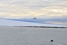
Other mammals occasionally observed include the wolf (Canis lupus), the polar bear (Ursus maritimus),[52] ermine (Mustela erminea), walrus (Odobenus rosmarus), Arctic hare (Lepus timidus), and reindeer (Rangifer tarandus).
The location of a secret Russian space weapons control facility is called Severnaya in the 1995 James Bond film GoldenEye.
Severnaya is the site of a Kaiju-controlled rogue Jaeger (giant mech) in the 2018 film Pacific Rim Uprising.
Severnaya is the site of the final act of the 2021 movie The Tomorrow War, where the protagonists locate a crashed spaceship holding the dormant White Spike Aliens.