Shannan, Tibet
It is bounded by the city of Lhasa to the north, Nyingchi to the east, Shigatse on the west and the international border with India and Bhutan on the south.
[9] A legend that attests to the position of Lhoka region in the annals of Tibetan history states that human beings are the creation of a union between a sacred monkey and women.
[10] The first king in Tibetan history, Nyatri Tsenpo, really a mere chief of the Yarlong tribe, began ruling over the Yarlung valley in the beginning of second century BC.
During the reign of the ninth king, Budegong, agriculture flourished and he was able to mobilize the people to excavate canal, channelling water to irrigate the flatland.
[10] A formal forming system came into existence during the reign of Yixiulie, the eleventh king, when he devised standard measurement units for allocating farmland and counting livestock.
Around the 6th century AD, the Yarlung Valley became a society which smelted a variety of materials including iron, copper and silver to produce weapons and other objects.
[10] On May 23 of 1951, a Tibetan delegation signed the Seventeen Point Agreement with the central government of the People's Republic of China for the "peaceful liberation of Tibet".
The wide Yarlung River flowing from west to east (between Quxu and Gyacha) also known as Tsongpo and the Brahmaputra River in India and Jamuna in Bangladesh, and its tributaries flows through the middle and lower stretches of the city and is bounded by Lhasa on the north, Nyingchi on the east, Shigatse to the west and international border that extends to 630 kilometres (390 mi) with India and Bhutan.
The region is also credited with the first "cultivated lands, measured fields, water irrigation, storing the forage grass, moulding metal, and many other techniques".
[6] The Yarlung State Scenic Region is one type which has the snow-covered mountains, glaciers, pastures, river valley, alpine vegetation and historical monuments and folk customs and art forms.
Like mountains, lakes are considered sacred by Tibetan people, the principle being that they are the dwelling places of protective deities and therefore invested with special spiritual powers.
Samding Monastery is where Dorje Phagmo, one of the few important female lamas in Tibet, stayed and presided, and stands to the south of Lake Yamdrok Yumtso.
Ever since the time of Gendun Gyatso, the Second Dalai Lama, who formalised the system, the Regents and other monks have gone to the lake to seek guidance on choosing the next reincarnation through visions while meditating there.
[17] It is also believed by pilgrims that they can see visionary images of their future by looking at the lake intently in silence with deep devotion and reverence and by performing Buddhist rites.
[25] Shannan is marked by China with a geographical area of 79,700 square kilometres (30,800 sq mi) distributed over 1 district and 11 counties with a total population of 330,000.
[7][8] The economy of the city has undergone substantial progress in recent years following the reform policy and opening of the area by the Tibet Autonomous Region to development support from China and other countries.
This has also resulted in rural prosperity and even creation of a rich farming community who have established the first "farmers hotel" in the region, and investing in real estate.
[30] The city has more than 20 types of metal and non-metal mineral resources such as chromium, gold, copper, iron, antimony, lead, zinc, manganese, mica, crystal, jade and marble.
Light industries for processing of agricultural and livestock products and pharmaceuticals are widely adopted by replacing manual operation with mechanization and semi-mechanization.
The most significant handicrafts of the city, which have worldwide market, are the commercial products of utility, religious use and artistic crafts of the royal families of Tibet of the past.
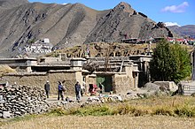
[6][7][8] The city has very unusual and rich historical monuments, natural geological features such as lakes and caves, scenic regions and religiously linked mountains.
The coffin is decorated at its head end with a statue of Lord Loyak Gyalo which is supposed to be shedding light on the dead king.
After Detsen's death, the Bon religious group of nobles who were opposed to Buddhism propagated by Dretsen completely destroyed the palace.
It is a seven-storied structure accommodating flat houses, horse stables, a mill, a workshop for weaving and dyeing, a pillbox and a jail.
It is surrounded by four temples which are known as the ling, representing the four continents amidst vast oceans to the north, south, east and west of Sumeru.
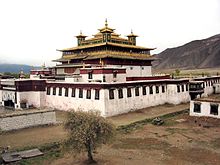
The monastery has undergone refurbishing and additions several times during the reigns of the Sakya sect without altering the basic concept of its original plan.
[5] Qingpo Meditation Caves are set at 3,400 metres (11,200 ft) elevation, surrounded by Narui Mountains on three sides with Yarlung Zangbo River flowing to its south.
[42] Many festivals are held in Lhoka region in its counties, district, monasteries and villages to celebrate the harvest season, the New Year or Losar and natural elements such as birds.
On this occasion birds are given a red carpet welcome at Linka with a tribute of food items such as the Tibetan Highland barley, wheat, peas and other grains on a platter placed on a table.
[7][8][46] From the time Tibet Autonomous Region has been opened for other countries, development of many infrastructure and social sectors have recorded dramatic progress such as education, telecommunications and tourism.