Shawangunk Ridge
[2] The English name, Shawangunk, derives from the Dutch Scha-wan-gunk, the closest European transcription from the colonial deed record of the Munsee Lenape, Schawankunk (German orthography).
[3] Whritenour has suggested that the name derives from the burning of a Munsee fort by the Dutch at the eastern base of the ridge in 1663 (a massacre ending the Second Esopus War).
Shawangunk appears nowhere in reference to the fort in the extensive, translated Dutch record of the Second Esopus War.
In the original Lenape, the word is tri-syllabic, Sha-wan-gun, although in an occasional 18th-century deed it is written with a fourth syllable.
[6] The trailing k is sub vocal and modifies the sound of the n.[7] European colonists began to truncate Shawangunk into "Shongum" (/ˈʃɒnɡʌm/ SHON-gum).
Shongum was mistakenly identified as the Munsee pronunciation by the Reverend Charles Scott writing on Shawangunk's etymology for the Ulster County Historical Society in 1861.
The Shawangunk Conglomerate was deposited over the Martinsburg Formation in thick braided river deposits during the Silurian (about 420 million years ago); both sequences of sedimentary rock were subsequently deformed in a continental collision associated during the assembly of the Pangean supercontinent during the Permian (about 270 million years ago).
This collision deformed strata within the ridge in a northward plunging series of asymmetric folds (e.g., anticlines and synclines) that are inclined gently westward.
Topography on the top of the northern Shawangunks is irregular due to a series of faults that form secondary plateaus and escarpments.
Ice caves are deep fissures in the conglomerate bedrock that retain ice through much of the summer, resulting in a cool microenvironment that supports several northern species such as black spruce, hemlock, rowan, and creeping snowberry (Gaultheria hispidula), and bryophytes such as Isopterygium distichaceum.
Lakes and ponds occurring on conglomerates tend to be clear, nutrient-poor, and very acidic, due to the limited buffering capacity of the bedrock.
The Open Space Institute of NY purchased the land and has signed it over to Minnewaska State Park Preserve.
The goal of the project was to develop "management objectives" for the properties, including those concerning permissible forms of public recreation and access.
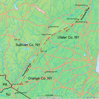
It generally follows the spectacular Shawangunk Ridge north, occasionally using abandoned roads and rail beds.
[24] The Skytop cliff is owned by the Mohonk Mountain House and rock climbing requires authorized guides.
Rock climbing is also permitted on the Peterskill and Dickie Barre cliff areas of Minnewaska State Park Preserve.
In 1930, the Conservation Department built a 60-foot-tall (18 m) Aermotor LS40 steel fire lookout tower and observers cabin on Sayers Hill (Pocatello Mountain).
The tower was purchased with funds provided from the county and town, to protect the eastern and southern slopes of the Shawangunk Ridge.
[26] In 1912, the Conservation Commission built a wood fire lookout tower on the ridge east of Ellenville on High Point.
[26] In 1948, the Conservation Department built a 35-foot-tall (11 m) Aermotor steel fire lookout tower on the ridge northeast of Wurtsboro.