Shenandoah National Park
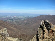
The park is long and narrow, with the Shenandoah River and its broad valley to the west, and the rolling hills of the Virginia Piedmont to the east.
As stated in the foundation document:[3] Shenandoah National Park preserves and protects nationally significant natural and cultural resources, scenic beauty, and congressionally designated wilderness within Virginia’s northern Blue Ridge Mountains, and provides a broad range of opportunities for public enjoyment, recreation, inspiration, and stewardship.The park encompasses parts of eight counties.
The park stretches for 105 miles (169 km) along Skyline Drive from near the town of Front Royal in the northeast to near the city of Waynesboro in the southwest.
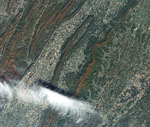
[6][7] The park is located along the western part of the Blue Ridge anticlinorium, a regional-scale Paleozoic structure at the eastern margin of the Appalachian fold and thrust belt.
Rocks within the park were folded, faulted, distorted, and metamorphosed during the late Paleozoic Alleghanian orogeny (325 to 260 million years ago).
[8] The rugged topography of Blue Ridge Mountains is a result of differential erosion during the Cenozoic, although some post-Paleozoic tectonic activity occurred in the region.
[9][10] Legislation to create a national park in the Appalachian mountains was first introduced by freshman Virginia congressman Henry D. Flood in 1901, but despite the support of President Theodore Roosevelt, failed to pass.
Stephen Mather, the first NPS director, saw a need for a national park in the southern states, and solicited proposals in his 1923 year-end report.
The commonwealth of Virginia slowly acquired the land through eminent domain, eventually giving it to the U.S. federal government to establish the national park.
Upon Mather's death in 1929, the new NPS director, Horace M. Albright also decided that the federal agency would only accept vacant land, so even elderly residents would be forced to leave.
[16] Although Byrd and Carson convinced Congress to reduce the minimum size of Shenandoah Park to just over 160,000 acres (250.0 sq mi; 647.5 km2) to eliminate some high-priced lands, in 1933 newly elected President Franklin D. Roosevelt decided to also create the Blue Ridge Parkway to connect to then-under-construction Skyline Drive on the Shenandoah National Park ridgeline, which required additional condemnations.
Although later discredited, the report depicted the local population as very poor and inbred and was soon used to support forcible evictions and burning of former cabins so residents would not sneak back.
In 1933, Sherman and journalist Thomas Henry published Hollow Folk[17] drawing pitying eyes to local conditions and "hillbillies.
"[18][19][20] As in many rural areas of the time, most remote homesteads in the Shenandoah lacked electricity and often running water, as well as access to schools and health facilities during many months.
[21] Carson had had ambitions to become governor in 1929 and 1933, but Byrd instead selected George C. Peery of Virginia's southwestern region to succeed easterner Pollard.
[22] After winning the election, Peery and Carson's successor would establish Virginia's state park system, although plans to relocate reluctant residents kept changing and basically failed.
Carson had hoped to head that new state agency but was not selected because of his growing differences with Byrd, over fees owed his brother and especially over the evictions that began in late 1933 against his advice but pursuant to new federal policies and that garnered much negative publicity.
However, some refused to cooperate to any extent, others wanted to continue to use resources now protected (including timber or homes and gardens vacated by others), and many found the permit process arbitrary.
As one of his final acts, Carson wrote the new NPS director, Arno B. Cammerer, urging that 60 people over 60 years of age whose plots were not visible from the new Skyline Drive not be evicted.
When evictions kept creating negative publicity in 1935, photographer Arthur Rothstein coordinated with the Hollow Folk authors and then went to document the conditions they claimed.
The first CCC camp in Virginia was established in the George Washington National Forest near Luray, and Governor Pollard quickly filled his initial quota of 5,000 workers.
Shenandoah National Park was finally established on December 26, 1935, and soon construction began on the Blue Ridge Parkway that Byrd wanted.
Their plan included a separate facility for African Americans at Lewis Mountain—a picnic ground, a smaller lodge, cabins and a campground.
In the 1990s, the park hired cultural resource specialists and conducted an archeological inventory of existing structures, the Survey of Rural Mountain Settlement.
Eventually, the park's new focus on cultural resources coincided with agitation from a descendant's organization known as the Children of Shenandoah, which resulted in the removal of questionable interpretive displays.
The distance from the trailhead to the base of the falls is 0.7 mi (1.1 km), although the trail continues beyond that point, crossing the creek and connecting with the Rose River fire road.
According to the United States Department of Agriculture, the plant hardiness zone at Big Meadows Visitor Center (3514 ft / 1071 m) is 6a with an average annual extreme minimum temperature of -7.1 °F (-21.7 °C).
Other commonly found plants include oak, hickory, chestnut, maple, tulip poplar, mountain laurel, milkweed, daisies, and many species of ferns.
About thirty live in the park year-round, including the barred owl, Carolina chickadee, red-tailed hawk, and wild turkey.
[41] Thirty-two species of fish have been documented in the park, including brook trout, longnose and eastern blacknose dace, and the bluehead chub.