Sherman County, Oregon
The county is named for William Tecumseh Sherman, a Union general in the American Civil War.
As the pioneers felt crowded in the new settlements of western Oregon, they turned east to the Columbia Plateau for new opportunities.
The county's first white settler was William Graham, who located at the mouth of the Deschutes River in 1858.
[3] Homesteaders, eager for land, arrived in the 1880s by steamboat, stagecoach and wagon.
Following the addition of a portion of Wasco County, Moro became the eventual winner.
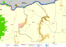
Sherman County is located in the central northern part of Oregon, east of the Cascade Range.
Sherman County is mostly flat, being part of the Columbia Plateau; its highest point is at an unknown location at 3,004 feet (916m).
The Northern Oregon Regional Corrections Facility (Norcor), a short-term jail, serves Sherman, Gilliam, Hood River, and Wasco counties.
[15] Although Sherman County is located in Central Oregon, its politics are more-aligned with the eastern parts of the state with most of its voters being affiliated with the Republican Party.
No Democrat has carried this county in a presidential election since Lyndon Johnson in 1964.
It is also home to the Biglow Canyon Wind Farm, the largest project of its kind in Oregon.