Shuafat
[3] Shuafat borders Pisgat Ze'ev and Beit Hanina on the north, Shu'fat refugee camp on the east, French Hill on the south, and Ramat Shlomo on the west.
It is possible that the name of this town was altered by the Crusaders or that it was slightly modified from the word Sh'af (plural Sh'afat), which means mountain top.
Clermont-Ganneau noted that the Hebrew name Jehoshaphat does not contain the 'ayin that exists in Sha'fat, and therefore, this tale was an "entirely artificial tradition", which was possibly influenced by the nearby valley of Josaphat.
[19] During an archaeological salvage dig conducted near the Shuafat refugee camp in preparation for the laying of the tracks for the Jerusalem Light Rail system, the remains of a Jewish settlement from the Roman period were discovered.
[22][2] This settlement is thought to have been inhabited by elite Jewish families, including priests, who stayed close to Jerusalem after its destruction, possibly in anticipation of the temple's future restoration.
[24][2][13] The presence of the public bathhouses, the delay in finding Jewish ritual baths, and the discovery of imported Italian and Greek wine produced by non-Jews, which the very purity-concerned Jews of the time would have avoided, made researchers at first speculate whether the settlement might have been a mixed Jewish-Roman (pagan) one, with the bathhouses operated by Jews for the benefit of Roman soldiers.
[24][21] The quality of the buildings and other findings, such rich coin hoards, cosmetics, stone vessels and imported wine, attest to the wealth of the inhabitants.
[25][24] The abandoned or destroyed site was resettled on a smaller scale in the second–fourth centuries CE, with agricultural terraces recently exposed west of Shuʽfat Street.
[26][27] In March 1179, it was noted that its revenues went to the abbey of St Mary of Mount Sion as the result of a grant made by Anselm de Parenti.
"[35] The French explorer Guérin visited in 1863 and noted that the village was situated on an elevated plateau "from which one can make out perfectly the cupolas and minarets of Jerusalem," and that it counted 150 inhabitants.
[47] The town of Shuafat was to be the most northernmost point of the corpus separatum proposed in 1947 for Jerusalem and its surrounding villages, which "in view of its association with three world religions" was to be "accorded special and separate treatment from the rest of Palestine and should be placed under effective United Nations control".
[48] In mid-February, during the 1948 Arab–Israeli War, Abd al-Qadir al-Husayni, leader of Palestinian irregulars in the area, tried to persuade the residents of Shuafat to attack the neighbouring Jewish village of Neve Yaakov but the invitation was declined.
[55] In the wake of the 1948 war, the Red Cross accommodated Palestinian refugees in the depopulated and partly destroyed Jewish Quarter of Jerusalem's Old City.
[57] Conditions became unsafe for habitation due to lack of maintenance and sanitation, but neither UNRWA nor the Jordanian government wanted the negative international response that would result if they demolished the old Jewish houses.
[57] Most of the refugees refused to move, since it would mean losing their livelihood, the market and the tourists, as well as reducing their access to the holy sites.
[2] According to ARIJ, Israel has illegally and unilaterally redrawn the boundaries of Jerusalem Municipality, and confiscated 3,989 dunams of Shu’fat land (47% of the total town's area) in order to establish five Israeli settlements:[59] The Shuafat refugee camp is the only Palestinian refugee camp located inside Jerusalem or any other Israeli-administered area.
[63] In July 2001, the Israeli authorities destroyed 14 homes under construction in Shuafat on the orders of then mayor Ehud Olmert, who said the structures were built without permits.
Olmert said the houses were being constructed on public land in a "green area" and posed a security threat to the Jews of Pisgat Zeev.
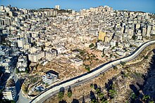
[65] According to Isabel Kershner of the New York Times, Shuafat suffered from an absence of municipal planning, overcrowding, and potholed roads in 2007.
In the 1990s a new route was built to the east of the neighbourhood, a dual carriageway with 3 lines in each direction, relieving traffic congestion along the road.