Tulkarm
This page is subject to the extended confirmed restriction related to the Arab-Israeli conflict.Tulkarm or Tulkarem (Arabic: طولكرم, Ṭūlkarm) is a Palestinian city in the West Bank, the capital of the Tulkarm Governorate of the State of Palestine.
[9] Isaiah Press and Dov Zudkevitz suggest the true site may be somewhat west of Tulkarm, at Tel Zureiqiya [he] in the Poleg basin.
[10][11] During the Ayyubid era, after the Muslim reconquest of Palestine under Sultan Saladin in 1187, the first families to settle in Tulkarm were from the Kurdish clan of Zaydan.
[12] Among the Arab families were the Fuqaha clan, who were considered ashraf (related to the Islamic prophet Muhammad) and served as the ulama (religious scholars) of the village.
They largely engaged in agriculture and animal husbandry, supplying hides to leather merchants in the coastal villages, retaken from the Crusaders in the second half of the 13th century.
Afterward, Sultan Suleiman the Magnificent (r. 1520–66) transferred Tulkarm's waqf to the al-Jawhariyya Madrasa (Commons), located in the Muslim Quarter, northwest of the al-Aqsa Mosque.
[12] In 1596 Tulkarm appeared in Ottoman tax registers as being in the nahiya (subdistrict) of Qaqun, which was a part of the sanjak (district) of Nablus.
Because of the decentralized nature of the Ottoman state, these families and their successors in later centuries ruled the area with a high degree of autonomy.
[citation needed] This was in reaction to the Zaydan having forced Tulkarm's residents to harvest and process the village's grains for taxation purposes.
Consequently, political power in Tulkarm passed to the Badran clan, while the Fuqaha family took control of administering the "waqf" lands, firmly establishing them as the village's religious leaders.
[14][15] Following the adoption of the Ottoman Land Code in 1858, the musha (collective landownership) system was gradually abrogated and residents were required to register their property with the central authorities.
The fellahin were wary of registering their names for fear of military conscription by the Ottoman state and instead entrusted various elite clans with the role of landlords, who were in effect absentee owners.
This altered the area's social structure, with the Samara, al-Hajj Ibrahim and Hanun clans legally obtaining vast swathes of Tulkarm's lands.
[17] During this time, the Ottoman authorities granted the village an agricultural plot of land called Ghabat Tulkarm in the former confines of the Forest of Arsur (Ar.
[18][19] In 1882 the Survey of Western Palestine described Tulkarm as a "long straggling village, on high ground", surrounded by arable land and rock.
Tulkarm's center shifted from the Old Mosque to an empty space in the northwest as the town expanded northward with the construction of government buildings, a post office, a school and a hospital in that area.
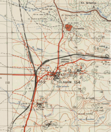
[24] In 1908, Tulkarm became a major rail junction on the Hejaz Railway line running up from Egypt and southern Palestine to Haifa and Acre in the northwest, Jerusalem, Nablus and Ramallah to the south, Lebanon to the north, and Syria and Transjordan to the east.
In order to cope with a significant increase in population and unorganized infrastructural development, a civil planning scheme was designed for Tulkarm and its satellite villages in 1945.
General Commander of the Revolt Abd al-Rahim al-Hajj Muhammad hailed from Dhinnaba, today part of Tulkarm municipality, and led many operations in the region.
During the early months of the First Intifada, 16 May 1989, Muhammad As'ad Fokhah, 50 years old, from Shuweika, died in Megiddo prison after a three-day hunger strike.
Yitzhak Rabin reported to a Member of Knesset that Fokhah died of a heart attack caused by dehydration and that the military investigation found that prison staff had acted in accordance with orders.
News reports include videos of this attack, as well as assertions by the Israel Defense Forces that it is rooting out terrorism; and that it "undertakes all feasible precautions to avoid damaging essential infrastructure," while acknowledging that these "operations in the area have caused unavoidable harm to certain civilian structures.
It is bordered by the 1948 ceasefire line, with Israel's Central and Haifa Districts to the west, and Palestine's Qalqilya and Ramallah and al-Bireh Governorates to the south.
In the past, Tulkarm was a caravan station and a trading center for products from the city's surrounding villages and farms, as well as a point from which armies crossed to Egypt and the Levant (al-Sham).
In the past it was a junction of the coastal railroad from north of Haifa to Cairo and a branch of the narrow gauge Hejaz railway to Damascus.
[citation needed] According to the 1922 census of Palestine conducted by the British Mandate authorities, Tulkarm had a population of 3,350 (3,109 Muslims, 208 Christians, 23 Jews, eight Samaritans, one Baha'i, and one Druze).
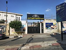
Tulkarem governor Issam Abu Bakr said that the school was named after “martyr Salah Khalaf in order to commemorate the memory of this great national fighter”.
[25] A Tulkarm amusement park called Mega Land attracts tens of thousands of visitors on Muslim holidays.