Siege of Godesberg
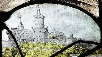
On top of the mountain sat a formidable fortress, similarly named Godesburg, built in the early 13th century during a contest over the election of two competing archbishops.
By the mid-16th century, the Godesburg was considered nearly impregnable and had become a symbol of the dual power of the Prince-electors and Archbishops of Cologne, one of the wealthiest ecclesiastical territories in the Holy Roman Empire.
The 1555 agreement settled religious problems in the Empire with the principle Cuius regio, eius religio: the subjects of a secular prince followed the religion of their sovereign.
Ecclesiastical reservation excluded the territories of the imperial prelates (bishops, archbishops, abbots or abbesses) from cuius regio, eius religio.
[5] Agnes of Mansfeld-Eisleben was a Protestant canoness (meaning that she was a woman living in a religious community, but not bound by a perpetual vow) at a convent in Gerresheim, today a district of Düsseldorf.
[8] With the support of Adolf von Neuenahr and the Count Solms, Gebhard secured some of the northern and eastern portions of the Electorate, where he held a geographical advantage in his proximity to the rebellious Dutch provinces.
Other supporters were frustrated by Gebhard's chronic inability to pay his troops, or intimidated by threats of Rudolf II, Holy Roman Emperor.
[8] The Godesburg foundation stone was laid on 15 October 1210 upon the order of Dietrich of Hengebach, the Archbishop of Cologne, who was himself in disputed possession of the Electorate and fighting to keep his position.
[9] Although his competitors deposed Dietrich in 1212, his successors finished and enlarged the fortress;[10] it featured in chronicles of the subsequent centuries as both a symbolic and physical embodiment of the power of the archbishop of Cologne in his many struggles for regional authority in secular and ecclesiastical matters.
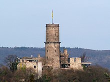
[12] Successive archbishops continued to improve the defenses with stronger walls, adding levels to the central Bergfried, which was cylindrical, not square like many medieval donjons.
The physical location on the mountain did not permit the star-shaped trace italienne; nevertheless, the Godesburg's cordons of thick, rounded walls and massive iron-studded gates made its defenders formidable adversaries.
[13] Fortifications such as this, and the star-shaped fortresses more commonly found in the flatter lands of the Dutch Provinces, increasingly made 16th-century warfare both difficult and expensive; victory was not simply a matter of winning a battle over the enemy's army.
[16] The Godesburg was defended by Lieutenant Colonel Felix Buchner, Captain of the Guard Eduard Sudermann, a garrison of soldiers from the Netherlands, and a few cannons.
[18] According to contemporary sources, around 180 people lived in the facility, including peasants, the Dutch soldiers defending it, and an unknown number of women and children.
[20] Other prisoners held in the Godesburg included Gebhard von Bothmer, the suffragan (auxiliary bishop) of Hildesheim, and Captain Ranucino from Florence, the captured commander of Deutz, across the Rhine from Cologne.
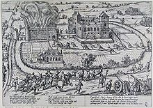
[23] On 18 November, the first day of the siege, Ferdinand sent a trumpeter and formally asked the fortress to surrender; the defending garrison replied that they had sworn their allegiance to Gebhard and would fight to the death for him.
[34] Ferdinand reported on the siege's progress in a letter to his older brother, Duke Wilhelm, dated 15 December 1583: "The fortress stands on solid rock.
[40] Amidst the flames and rubble, Arenberg's and Ferdinand's troops tried to storm the castle, but found their way blocked by masses of debris created by their own explosives.
[38] Furthermore, although close to half of the garrison had perished in the explosion and subsequent collapse of the fortifications, those who remained offered staunch resistance by throwing rocks on the approaching attackers, causing a large number of casualties.
[38] In frustration, 40 or 50 of the attackers tied together two ladders and crawled through the sluice-ways of the garderobe (latrines) that emptied on the hillside, thus gaining access to the interior of the castle.
[48] Ernest's troops, under his brother's command, saturated the region, and the 7.3 kilometers (4.5 mi) between Godesberg and Bonn bore a greater resemblance to a military camp than to a road.
In addition to damage to the towns and cities, Ernest's supporters managed to restrict imports and exports to and from the Electorate, not only crippling Gebhard's financial resources but resulting in economic hardship for the inhabitants.
[49] Advances in military architecture over the previous century had led to the construction or enhancement of fortresses that could withstand the pounding of cannonballs and mortar shells.
For both Gebhard and Ernest, winning the war required mobilizing enough men to encircle a seemingly endless array of enemy artillery fortresses.
The stone is a block of black marble with a Latin inscription commemorating the construction of the fortress by Dietrich I von Hengebach in 1210: Anno · D(omi)ni · M·C·C·X · Gudensburg · Fundatum · E(st) · A · Teoderico · Ep(iscop)o · I(n) · Die · Mauror(um) · M(a)r(tyrum).
Wittelsbach authority in northwestern German territories endured until the mid-18th century, with the election of a succession of Bavarian princes to the archbishop's throne and to the prince-elector's seat.
[57] The shift of the emperor's orb from the House of Habsburg to the Wittelsbach family, albeit a brief event, was only resolved by the ascension of Maximilian III Joseph who, with the Treaty of Füssen, eschewed any imperial pretensions.
[60] Finally, the German tradition of local and regional autonomy created structural and cultural differences in the Holy Roman Empire, compared to the increasingly centralized authority of such other European states as France, England, and Spain.
The unabashed intervention of Spanish, French, Italian, Dutch, English and Scots mercenaries in the war, as well as the influence of papal gold, changed the dynamic of internal German confessional and dynastic disputes.
The great "players" of the early modern European political stage realized that they could enhance their own positions vis-a-vis one another by assisting, promoting or undermining local and regional competition among the German princes, as they did in the feud between Gebhard and Ernest.