Sigur Plateau
[3] The Sigur Plateau is notable as an important wildlife corridor in the Western ghats to sustain elephant and tiger numbers and their genetic diversity.
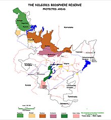
[7] The Western Ghats, the Nilgiri Sub-Cluster (more than 6,000 square kilometres (2,316.6 sq mi)), including all of Mudumalai National Park and the reserve forests of the Sigur Plateau, is under consideration by the UNESCO World Heritage Committee for selection as a World Heritage Site.
[8] In the late 1700s, Tipu Sultan maintained a fort and trading route between the Kingdom of Mysore and Travancore, along the Moyar River here.
[13] On 26 August 2010, Jairam Ramesh the Indian Minister of State for Environment and Forests asked Chief Minister of Tamil Nadu M Karunanidhi for the Tamil Nadu government to favourably consider a proposal from his ministry to declare the Sigur Plateau in the Nilgiris as a buffer zone of the Mudumalai National Park.
[19] Across the Moyar River, the Sigur Plateau is adjacent on the north to the Mysore Plateau, referred to as the Talamalai Range, bordered on the west by Nilgiri District, north by Mysore District, east by the Sattyamangalam Range and south by the Moyar River and Gorge.
The Sigur river valley acts as a crucial micro-habitat for herbivores, especially elephants, gaur and sambar and carnivores such as tiger, leopard, wild dog (dhole), sloth bear and striped hyaena for feeding, resting and denning.
[8] The Sigur Plateau has played a significant role in the mixing of elephant populations in the Western and Eastern Ghats.
[24] These forests are home to indigenous tribal people belonging largely to the Kasaba sub-group of the Irular community.
They include, from east to west: Sigur, Anaikatti, Chokkanalli, Vazhaithottam, Sholur, Masinagudi, Boothanatham, Mavanhalla, Bokkapuram, Hundi Moyar, Singhara, Tippakadu, Siriyur, Chamanatham and Kurumbarpallam.
Much to the relief of local residents, officials and tourists, Veerapan was killed by Tamil Nadu Government in October 2004.
[30] These are cattle grazing, coffee and tea plantations and other crops cultivation, private tourist resorts, Invasive weeds, fuel wood collection, non-timber forest products (NTFP) collection, legal status of the corridor, and vehicular traffic particularly during night hours.
[30] Weed species, especially Lantana camara but also Parthenium, Stachytarpheta indica, Dodonaea viscosa, Euphorbia antiquorum, and Opuntia dillennii are widely distributed and are invading and degrading the quality of forage on the plateau.
[32] The major impact of private resorts on the corridor areas are: fragmentation and destruction of habitats due to invasion of unpalatable weeds, loss of forest connectivity between habitats due new buildings construction and agriculture fields, including installation of barbed wire and electric fences, increasing rate of dependence by local communities on natural resources for fuel wood collection, cattle grazing, fresh water supply and waste disposal.
There are 11 government tourist facilities within Mudumalai Wildlife Sanctuary or within reserve forest or revenue land and none of them are fenced.
[38] R.Venkitachalam (2014)Status and Distribution of the Endangered resident Gyps Vulture species in Nilgiri Bio-sphere Reserve, Western Ghats in India.WWF-Final Report.pp 21