Singapore River
The planning area shares boundaries with the following – River Valley and Museum to the north, Tanglin and Bukit Merah to the west, Outram to the south, and the Downtown Core to the east.
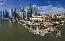
The Singapore River is approximately 3.2 kilometers long[3] from its source at Kim Seng Bridge to where it empties into Marina Bay; the river extends more than two kilometers beyond its original source at Kim Seng Bridge as Alexandra Canal, as far as the junction of Commonwealth Avenue.
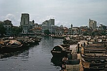
Historically, the city of Singapore initially grew around the port so the river mouth became the centre of trade, commerce and finance.
[5] At the same time, it brought in water pollution caused by the disposal of garbage, sewage and other by-products of industries located along the river's banks.
The sources of water pollution in the Singapore River and Kallang Basin included waste from pig and duck farms, unsewered premises, street hawkers and vegetable whole sellers.
The clean-up cost the government $300 million at the time and involved the relocation of about 4,000 squatters, along with hawkers and vegetable sellers, whose daily waste flowed into the river.
The government then completely dredged foul-smelling mud from the banks and the bottom of the river, clearing the debris and other rubbish.