Skardu
Skardu (Urdu: سکردو, romanized: skardū, Tibetan script: སྐར་མདོ, pronounced [skərduː]) is a city located in Pakistan administered Gilgit-Baltistan in the disputed Kashmir region.
It is situated at an average elevation of nearly 2,500 metres (8,202 feet) above sea level in the Skardu Valley, at the confluence of the Indus and Shigar rivers.
"[5] The two referenced "high places" are Shigar city, and the high-altitude Satpara Lake[5] Local people might tend to write the name as སྐར་དོ་ according to how they pronounce it.
Active erosion in the nearby Karakoram Mountains has resulted in enormous deposits of sediment throughout the Skardu valley.
[7] The Skardu region was part of the cultural sphere of Buddhist Tibet as early as the founding of the Tibetan Empire under Songtsen Gampo in the mid 7th-century CE.
[5] Given the region's close proximity, Skardu remained in contact with tribes near Kashgar, in what is now China's westernmost province of Xinjiang.
[5] During his reign, Makpon Bokha imported craftsmen to Skardu from Kashmir and Chilas to help develop the area's economy.
[9] Sikhs traditionally believe that Guru Nanak, the founder of Sikhism, visited Skardu during his second udasi journey between 1510 and 1515.
[14] Gurudwara Chota Nana Kiana, locally known as Asthan Nanak Peer, is believed to be the place where the Guru stayed in Skardu.
When the Raja of Laddakh, Jamyang Namgyal, attacked the principalities in the district of Purik (Kargil), annihilating the Skardu garrison at Kharbu and putting to sword a number of petty Muslim rulers in the Muslim principalities in Purik (Kargil), Ali Sher Khan Anchan left with a strong army by way of Marol and, bypassing the Laddakhi army, occupied Leh, the capital of Laddakh.
In 1839, Dogra commander Zorawar Singh Kahluria defeated Balti forces in battles at Wanko Pass and the Thano Kun plains, clearing his path for the invasion of the Skardu valley.
[23] He seized Skardu Fort on behalf of the Dogra dynasty based in Jammu, under the suzerainty of the Sikh Empire at that time.
[3] Singh's forces massacred a large number of the garrison's defenders, and publicly tortured Kahlon Rahim Khan of Chigtan in front of a crowd of local Baltis and their chiefs.
Genealogy of Maqpon rulers:[27] (May 1840 Dogra invasion) In the early 1500s, Sultan Said Khan of the Timurid Yarkent Khanate, of what is now Xinjiang, raided Skardu and Baltistan.
[33] In 1839, Dogra commander Zorawar Singh Kahluria defeated Balti forces in battles at Wanko Pass and the Thano Kun plains, clearing his path to invade the Skardu valley.
[3] Singh's forces massacred a large number of the garrison's defenders, and publicly tortured Kahlon Rahim Khan of Chigtan in front of a crowd of local Baltis and their chiefs.
[36] Baltis under the leadership of Raja Ahmed Shah soon also rebelled against the Dogras, so Maharaja Gulab Singh dispatched his commander Wazir Lakhpat to recapture Skardu.
[36] The raja of the Baltis was forced to pay an annual tribute to the Dogra maharaja in Jammu, and also to supply the fort's provisions.
[36] Military commanders held real governing power in the area until 1851, when Kedaru Thanedar was installed as a civilian administrator of Baltistan.
[36] Under the administration of Mehta Mangal between 1875 and 1885, Skardu's Ranbirgarh was built as his headquarters and residence,[36] as well as a cantonment and various other government buildings.
[38][39] Major Aslam Khan took over the command of the Gilgit Scouts, organized a force of some 600 men from the rebels and local recruits, and launched attacks on the remaining parts of the State under Indian control.
[41] The Skardu garrison was defended by a contingent of 6th Jammu and Kashmir Infantry under the command of Col. Sher Jung Thapa.
[7] Skardu is located along the Kohistan-Ladakh terrane, formed as a magmatic arch over a Tethyan subduction zone that was later accreted onto the Eurasian Plate.
[7] Numerous complex granitic pegmatites and a few alpine-cleft metamorphic rock deposits are found in the Shigar Valley and its tributaries.
Shigar Valley contains the Main Karakoram Thrust separating the metasediments (chlorite to amphibolite grade) on the Asian plate from the southern volcanoclastic rocks of the Kohistan-Ladakh island arc.
The main tourist season is from April to October; at other times of the year, the area can be cut off for extended periods by the snowy, freezing winter weather.
With an area of approximately 3,000 square kilometres (1,158 sq mi), the plains extend all the way to Ladakh and provide a habitat for snow leopards, ibex, Tibetan blue bears and wild horses.
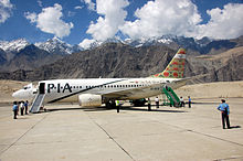
Roads in and out of Skardu can be blocked for extended periods of time, sometimes leaving air travel as the only feasible alternative.
It is 6 km (4 mi) south of Skardu city and is at an elevation of 2,700 metres (8,900 ft) above mean sea level.
[51] It is a multipurpose project, which will produce 17.36 megawatts hydro generation, irrigate 15,000 acres (61 km2) of land and provide 13 cusecs drinking water daily to Skardu city.