Slavonia
Even though archaeological finds of Illyrian settlements are much sparser than in areas closer to the Adriatic Sea, significant discoveries, for instance in Kaptol near Požega have been made.
The conquest was completed in 11 BC, when the Roman province of Illyricum was established, encompassing modern-day Slavonia as well as a vast territory on the right bank of Danube.
[11] After the collapse of the Western Roman Empire, which included the territory occupied by modern-day Slavonia, the area became a part of the Ostrogothic Kingdom by the end of the 5th century.
[12] After the fall of the Avar Khaganate at the beginning of the 9th century, in Lower Pannonia there was a principality, governed by Slavic rulers who were vassals of Francs.
Further westward efforts of the Turkish forces presented a significant threat to Zagreb and the rest of Croatia and the Hungarian kingdom, prompting a greater defensive commitment by the Habsburg Monarchy.
One year after the 1547 truce ended, Ivan Lenković devised a system of fortifications and troops in the border areas, a forerunner of the Croatian Military Frontier.
[34] By the 1860s, failure of the policy became apparent, leading to the Austro-Hungarian Compromise of 1867 and creation of a personal union between the crowns of the Austrian Empire and the Kingdom of Hungary.
Pursuant to the agreement, the Yugoslav government retained control of defence, internal security, foreign affairs, trade, and transport while other matters were left to the Croatian Sabor and a crown-appointed 'Ban'.
The regime introduced anti-semitic laws and conducted a campaign of ethnic cleansing and genocide against Serb and Roma populations,[47] exemplified by the Jasenovac and Stara Gradiška concentration camps,[48] but to a much lesser extent in Slavonia than in other regions, due to strategic interests of the Axis in keeping peace in the area.
[50][page needed] Armed resistance soon developed in the region, and by 1942, the Yugoslav Partisans controlled substantial territories, especially in mountainous parts of Slavonia.
[51] The Serbian royalist Chetniks, who carried out genocide against Croat civilian population,[52] struggled to establish a significant presence in Slavonia throughout the war.
[53] After the war, the new Yugoslav government interned local Germans in camps in Slavonia, the largest of which were in Valpovo and Krndija, where many died of hunger and diseases.
The autonomy effectively increased after the 1974 Yugoslav Constitution, basically fulfilling a goal of the Croatian Spring movement, and providing a legal basis for independence of the federative constituents.
[56] In the 1980s the political situation in Yugoslavia deteriorated with national tension fanned by the 1986 Serbian SANU Memorandum and the 1989 coups in Vojvodina, Kosovo and Montenegro.
[63][64] Tensions escalated into the Croatian War of Independence when the Yugoslav National Army and various Serb paramilitaries attacked Croatia.
[73] Armed conflict in the eastern Slavonia, culminating in the Battle of Vukovar and a subsequent massacre,[74][75] also included heavy fighting and the successful defence of Osijek and Vinkovci.
[91] The boundaries of Slavonia, as a geographical region, do not necessarily coincide with the borders of the five counties, except in the south and east where the Sava and Danube rivers define them.
[97] The Pannonian Basin took shape through Miocenian thinning and subsidence of crust structures formed during Late Paleozoic Variscan orogeny.
[98] Ultimately, up to 3,000 metres (9,800 feet) of the sediment was deposited in the basin, and the Pannonian sea eventually drained through the Iron Gate gorge.
[100] The results of those processes are large plains in eastern Slavonia, Baranya and Syrmia, as well as in river valleys, especially along the Sava, Drava and Kupa.
[101] The two mountains, as well as Moslavačka gora, west of Pakrac, are possible remnants of a volcanic arc related to Alpine orogeny—uplifting of the Dinaric Alps.
[102] The Đakovo – Vukovar loess plain, extending eastward from Dilj and representing the watershed between the Vuka and Bosut rivers, gradually rises to the Fruška Gora south of Ilok.
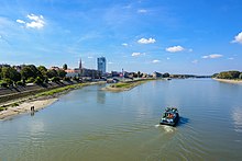
The length of the Danube, flowing along the eastern border of Slavonia and through the cities of Vukovar and Ilok, is 188 kilometres (117 miles), and its main tributaries are the Drava 112-kilometre (70 mi) and the Vuka.
Low winter temperatures and the distribution of precipitation throughout the year normally result in snow cover, and freezing rivers—requiring use of icebreakers, and in extreme cases explosives,[109] to maintain the flow of water and navigation.
[34][113] The Ottoman conquests initiated a westward migration of parts of the Croatian population;[114] the Burgenland Croats are direct descendants of some of those settlers.
[119] The 1940s and the 1950s in Yugoslavia were marked by colonisation of settlements where the displaced Germans used to live, by people from the mountainous parts of Bosnia and Herzegovina, Serbia and Montenegro, and migrations to larger cities spurred on by the development of industry.
A particular impact was made by Baroque art and architecture of the 18th century, when the cities of Slavonia started developing after the Ottoman wars ended and stability was restored to the area.
[167] Significant twentieth-century poets and writers in Slavonia were Dobriša Cesarić, Dragutin Tadijanović, Ivana Brlić-Mažuranić and Antun Gustav Matoš.
The most significant among those were from Hungarian, Viennese, Central European, as well as Turkish and Arab cuisines brought by series of conquests and accompanying social influences.
The best known winegrowing areas of Slavonia are centered on Đakovo, Ilok and Kutjevo, where Graševina grapes are predominant, but other cultivars are increasingly present.