Slioch
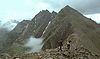
Slioch reaches an elevation of 981 metres (3,219 feet) and towers above the southeastern end of Loch Maree to give one of the best known and most photographed sights (from the A832 road) in the Highlands.
The return journey can be varied by taking in the subsidiary top of Sgurr an Tuill Bhain and then descending south into the corrie to join the uphill route.
Slioch is unusual in being bounded on three sides by waters flowing southeast (Lochan Fada), then southwest (Gleann Bianasdail) and finally northwest (Loch Maree).
Ordnance Survey maps show Lochan Fada as having two outlets at its south-east end, the second being via Gleann na Muice to Kinlochewe and Loch Maree.
Google Earth however shows no watercourse between the two ribbon lochans at the head of Allt Gleann na Muice, confirmed by its satellite elevation data, and by Bartholomew's Map [2]