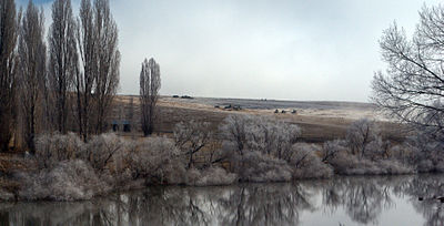
Snowy River
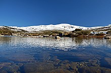
It originates on the slopes of Mount Kosciuszko, Australia's highest mainland peak, draining the eastern slopes of the Snowy Mountains in New South Wales, before flowing through the Alpine National Park and the Snowy River National Park in Victoria and emptying into Bass Strait.
While the river's course and surroundings have remained almost entirely unchanged, the majority of it being protected by the Snowy River National Park, its flow was drastically reduced in the mid 20th century, to less than 1% (as measured at Jindabyne), after the construction of four large dams (Guthega, Island Bend, Eucumbene, and Jindabyne) and many smaller diversion structures in its headwaters in New South Wales, as part of the Snowy Mountains Scheme.
[citation needed] In 1986, Jennings and Mabbutt mapped four geomorphic classes in the Snowy River Basin; (i) Australian Alps; (ii) the Monaro Tablelands; (iii) the East Victorian Uplands and (iv) the Gippsland Plains.
[6] The general distribution of rainfall over the Snowy River drainage basin (catchment) is controlled by orographic effects.
[7] The large flows in September and October are derived from snowmelt and hydrologically it is one of the key aspects that defines these mountain waterways.
Typically, Australian rivers can be defined as having highly variable river flows, with frequent zero flows even in humid areas[8] due to the extreme age of soils and consequent extremely high water absorption to absorb minimal phosphorus via proteoid and similar root types.
[8] Prolonged base flows over the summer months are another feature of these types of rivers, driven by snowmelt derived groundwater.
[11] Potentially, many of these waterfalls act as barriers for the large scale movement of aquatic species in the main stem of the Snowy River.
The flows required to drown out the largest barrier, Snowy Falls, is potentially larger than the environmental water releases to the river via Jindabyne Dam.
Around 70–80% of the Snowy River's length is protected by national parks, these include, from upstream to downstream: The aquatic flora and fauna of the snowy mountain snow melt rivers have evolved with the predictable seasonal hydrological snow melt peaks and constant summer base flow conditions.
Today, the river channel has contracted and the substrate has a heavy cover of sediment, overlying much of the cobble stone riverbed.
The bushfires of 2002–03, added to this problem as large amounts of sediment and organic matter were deposited in the river via tributary inflows.
Stratification can occur between October and March, but typically does not persist for very long in the Snowy River in the Jindabyne Gorge.
In the snowy mountains rivers unaffected by water diversions, large stands of filamentous algae are uncommon.
During 2008–09, the river pools of Jindabyne Gorge and the Dalgety uplands were typically dominated by blue green algae.
[citation needed] The composition of algae in the free flowing snow melt rivers are typically defined by diatoms.
[20] Caenid mayflies (riffles) and oligochaete worms (pool edges) are generally typical of the upland regulated Snowy River.
Marchant and Hehir (2002) reported that AUSRIVAS models (>50% probability) predicted Conoesucidae and elmids to be present in the upper Snowy River, but these taxa were not found in their study.
River scientists are currently undertaking studies to determine the flow thresholds for a range of riverine processes.
The Snowy River was initially utilised sustainably as a food and water resource by Indigenous Australians for around 30,000–40,000 years prior to European settlement.
Despite the cold climate in the river's higher reaches, the Ngarigo nation held territory around the Australian Alps and the Snowy Mountains in modern-day New South Wales.
In the 1950s and 1960s, as part of the Snowy Mountains Scheme, a network of four dams (i.e. Guthega, Island Bend, Eucumebene and Jindabyne) and many smaller water diversion structures were built to collect and divert 99% (as measured at Jindabyne) of the Snowy River's flow through the mountains, to provide more water to the Murray and Murrumbidgee River agricultural basins for irrigation.
By the 1990s, the reduced flows in the Snowy River became a major environmental concern in Victoria, New South Wales and across Australia.
After the scheme was built downstream flows were insufficient to keep the channel clear of vegetation or move sediment in the stream bed.
[24] Salt water intrusion extended seven to ten kilometres up the estuary and outdoor recreational activities were curtailed along the lower reaches of the river.
An independent candidate from the East Gippsland district, Craig Ingram, was elected to the Victorian Legislative Assembly in 1999 and re-elected in 2002 and 2006, on a platform to increase the flow of water in the Snowy River.
Although the Victorian, NSW and Federal governments promised that corporatisation would not lead to privatisation, in November 2005 they announced their intention to sell Snowy Hydro through a public float.
The poem The Man from Snowy River was written by 'Banjo' Paterson in 1890, which formed the basis of many subsequent works in film, TV and music theatre.