SoHo, Manhattan
The area's history is an archetypal example of inner-city regeneration and gentrification, encompassing socioeconomic, cultural, political, and architectural developments.
[21] Unlike Hudson Square, the South Village has traditionally appeared on maps of Community District 2, centered near the intersection of Houston Street and Avenue of the Americas.
[23][24] During the colonial period, the land that is now SoHo was part of a grant of farmland given to freed slaves of the Dutch West Indies Company, and the site of the first free Black settlement on Manhattan island.
[26] In the 18th century natural barriers – streams and hills – impeded the growth of the city northward into the Bayard estate, and the area maintained its rural character.
[26] After the war, Bayard, who had suffered financially because of it, was forced to mortgage some of the property, which was divided up into lots, but even then there was very little development in the area, aside from some manufacturing at Broadway and Canal Street.
[26] Once Broadway was paved and sidewalks were built there and along Canal Street, more people began to make their homes there, joining earlier arrivals such as James Fenimore Cooper.
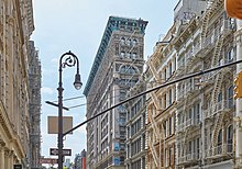
[26] By the mid-19th century, the early Federal- and Greek Revival-style homes were replaced by more-solid structures of masonry and cast iron, and along Broadway, large marble-skinned commercial establishments began to open, such as Lord & Taylor, Arnold Constable & Company and Tiffany & Company, as well as grand hotels such as the St. Nicholas and the Metropolitan.
[29] This dramatic shift in the nature of the neighborhood continued to drive out residents, and between 1860 and 1865 the Eighth Ward, which included the SoHo area, lost 25% of its population.
[29] This phase came to an end by the close of the 19th century, and as the center of the city continued to move uptown, the quality of the area declined.
[31] By the 1950s, the area had become known as Hell's Hundred Acres,[31] an industrial wasteland, full of sweatshops and small factories in the daytime, but empty at night.
The strength of cast iron permitted high ceilings with sleek supporting columns, and interiors became expansive and functional.
In the 1960s, the SoHo area was to have been the location of two enormous elevated highways that comprised the two branches of the Lower Manhattan Expressway, a Robert Moses project that was intended to create an automobile and truck through-route connecting the Manhattan Bridge and Williamsburg Bridge on the east with the Holland Tunnel on the west.
Nevertheless, through the efforts of Jane Jacobs, Tony D'Apolito, Margot Gayle, and other local, civic, and cultural leaders, as well as SoHo artist residents themselves, the project was derailed.
The upper floors of many of these buildings had been built as commercial Manhattan lofts, which provided large, unobstructed spaces for manufacturing and other industrial uses.
SoHo's location, the appeal of lofts as living spaces, its architecture, and its reputation as a haven for artists all contributed to this change.
[36][37] A backwater of poor artists and small factories in the 1970s, SoHo became a popular tourist destination for people seeking fashionable clothing and exquisite architecture, and home to some of the most expensive real estate in the country.
[38] SoHo's chain outlets are clustered in the northern area of the neighborhood, along Broadway and Prince and Spring Streets.
[39] Despite the significant change in the neighborhood's character in the previous decades, by the end of the 2010s the area's zoning still reflected its industrial heritage; any new residential development required special permits.
[40] As such, in 2019 the city began a public consultation process called "Envision SoHo/NoHo" to plan for future growth and manage change, and ultimately to bring land use rules in line with the mainly residential and commercial present-day reality of the neighborhood.
[45][46][47][48] A group of a half-dozen neighborhood groups, led by the Greenwich Village Society for Historic Preservation, put forth a "community alternative plan" which they claimed would create more affordable housing without any major new development, and a report attacking the city's plan, a claim that was challenged by the city and other civic organizations.
[51][52][53] In 2022, a team of over 2,000 players constructed a recreation of Soho in the sandbox game Minecraft, as part of the COVID-19 Build the Earth movement.
[54] For census purposes, the New York City government classifies SoHo as part of a larger neighborhood tabulation area called SoHo-TriBeCa-Civic Center-Little Italy.
[2] In 2018, an estimated 9% of SoHo and Greenwich Village residents lived in poverty, compared to 20% in all of Manhattan and 20% in all of New York City.
Based on this calculation, as of 2018[update], SoHo and Greenwich Village are considered high-income relative to the rest of the city and not gentrifying.
[58]: 14 The concentration of fine particulate matter, the deadliest type of air pollutant, in SoHo and Greenwich Village is 0.0095 milligrams per cubic metre (9.5×10⁻⁹ oz/cu ft), more than the city average.
[58]: 13 In SoHo and Greenwich Village, 4% of residents are obese, 3% are diabetic, and 15% have high blood pressure, the lowest rates in the city – compared to the citywide averages of 24%, 11%, and 28% respectively.
[58]: 6 The percentage of SoHo and Greenwich Village students excelling in math rose from 61% in 2000 to 80% in 2011, and reading achievement increased from 66% to 68% during the same time period.
[73] SoHo and Greenwich Village's rate of elementary school student absenteeism is lower than the rest of New York City.
[59]: 24 (PDF p. 55) [58]: 6 Additionally, 91% of high school students in SoHo and Greenwich Village graduate on time, more than the citywide average of 75%.