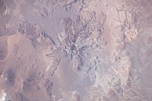
Socompa
Most of the northwestern slope of Socompa collapsed catastrophically 7,200 years ago to form an extensive debris avalanche deposit.
[8] The railway crosses the border between the two countries just below Socompa, making the volcano easily accessible despite its remote location.
[10] Rails and roads at Socompa go up to an elevation of 3,860 metres (12,660 ft); from there the volcano can be climbed from its southern, eastern and northern flank.
The largest historical eruption in the Central Volcanic Zone occurred in 1600 at Huaynaputina in Peru, and the recently most active volcano is Lascar in Chile.
[31] The summit area is surrounded by an inwards-dropping scarp that opens to the northwest and whose southern margin is buried by lava flows.
[27] Its volume is about 102 cubic kilometres (24 cu mi), making Socompa one of the largest stratovolcanoes with Quaternary activity.
[40] The deposit left by the collapse was first discovered on aerial photography in 1978 but it was correctly identified as a landslide in 1985;[28] at first, it was interpreted as a form of moraine,[41] then as a large pyroclastic flow[42] and the scar as a caldera.
[50] The total volume of material removed was about 19.2 cubic kilometres (4.6 cu mi), which was dilated as it flowed and eventually ended up as a deposit with a volume of 25.7 cubic kilometres (6.2 cu mi);[51] thorough mixing of the avalanche material occurred as the landslide progressed.
[28] A structure in the scar, named Domo del Núcleo, might either be a remnant of the pre-collapse volcano, or collapse debris.
[42] The growth rate of the volcano increased, in the aftermath probably due to the mass removal unloading the magmatic system.
[61] There is evidence in the deposit that a lava flow was being erupted on the volcano when the landslide occurred,[62] which together with the presence of pyroclastic fallout on the southwestern side of Socompa implies the event may have been started by volcanic activity.
[34] Such events are classified as catastrophic phenomena, and the debris avalanches associated with them can reach large distances from the original volcano.
[69] The fragmentation of rocks during the landslide and the fine material generated during this process might enhance the fluidity of the avalanche, allowing it to spread far away from the source.
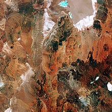
[73] The deposit spreads to a maximum width of 20 kilometres (12 mi) and is bounded by levees higher than 40 metres (130 ft), which are less prominent on the eastern side.
[71] As later parts of the collapse overrode the earlier segments, they formed a northeast-trending scarp in the deposit, across which there is a striking difference in its surface morphology.
[77] These blocks form an almost closed semicircle at the mouth of the collapse amphitheatre and in part retain the previous stratigraphy of the volcano.
As it descended, the landslide deposit filled a shallow valley that previously existed northwest of the volcano,[28] as well as a larger northeast-striking depression.
Around the same epoch, after the Eocene, the subduction angle increased beneath the Altiplano and caused the development of this plateau either from magmatic underplating and/or from crustal shortening; eventually the crust there became much thicker.
[83] One of these centres is El Negrillar just north of the collapse deposit,[84] which was active during the Pleistocene and issued andesite-basaltic andesite lavas unlike the eruption products of Socompa itself.
Other volcanoes such as Cordon de Puntas Negras and the rim of the large La Pacana caldera farther north are also influenced by this lineament.
The former crop out in the Sierra de Alameida and Alto del Inca west of Socompa and the latter as the 250-metre-thick (820 ft) Quebrada Salin Beds east of the volcano.
[9] In the summit area, hydrothermal alteration took place,[91] and clay, silt and sulphur bearing rocks are also found.
The area is windy and dry given that the volcano lies in the Desert Puna, with frequent snow cover,[19] there are penitentes[92] but no glaciers.
[97] Socompa features autotrophic communities associated with fumaroles and thermal anomalies at high altitude, between 5,750–6,050 metres (18,860–19,850 ft) of elevation.
[106][107] These stands are among the highest in the world and cover noticeably large surface areas despite their elevation,[19] and are fairly remote from other plant life in the region.
[109] The black-headed lizard and its relative Liolaemus porosus live on its slopes,[110] and mice have been observed in the summit area.
[2] An eruption 7,220 ± 100 years before present produced the El Túnel pyroclastic deposit on the western side of Socompa.
[118] The fumarolic activity occurs at at least six sites[119] and is relatively weak;[96] anecdotal reports indicate a smell of sulphur on the summit.
[123] The area is only thinly populated,[124] and apart from the Socompa railway station and mining camps west of the volcano, there is little infrastructure that could be impacted by future eruptions.
[127] In 2011, the Chilean mining company Escondida Mining was considering building a geothermal power plant on Socompa to supply energy;[128] the Argentine Servicio Geológico Minero agency started exploration work in January 2018 for geothermal power production.