Sotra Bridge
There exist plans to build a second bridge to either expand the road to four lanes, or carry a proposed extension of the Bergen Light Rail.
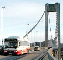
The concrete bridge crosses Knarreviksundet, which separates the island of Litlesotra, part of the Sotra archipelago, from the mainland and Bergen.
The issue was discussed in the municipal councils of Fjell and Sund, but they both concluded that there were more pressing needs on the islands' road network, so they did not want to prioritize a bridge.
[4] Another person who took up the initiative in the late 1950s was Rangvald Iversen, who was plant manager at Norwegian Talc at Knarrevik.
[6] The plans had been spurred by a large decrease in fishing during the late 1950s, and the need for increased tax revenue from new industries.
The framework for the plan started in 1961 with the creation of an inter-municipal cooperation,[7] which in 1964 resulted in the merger of the municipalities of Hjelme and Herdla to create Øygarden.
However, they wanted a separate company for Sotra and Øygarden, so extra tolls could be used to help finance road projects on the archipelago.
[10] On 29 June 1962, Fjell Municipality sent an official application to the County Governor to start planning, and this was sent onwards to the Directorate for Public Roads.
The plans called for the bridge to run south of Norwegian Talc, but it was later routed slightly north, so that the span could be reduced from 520 to 500 meters (1,710 to 1,640 ft).
The optimal location would be within the Norwegian Talc plant, and by placing the western pylon on a skerry, it was possible to reduce the span to 468 metres (1,535 ft).
[12] The Royal Norwegian Navy supported a taller bridge, but were more willing to reduce the height than the port authority.
A national committee was established in 1963 to make guidelines for clearances, and it recommended that 60 meters (200 ft) be used in fjords and sounds where very large ships, in particular cruise ships, would pass, while 50 meters (160 ft) would permissible for minor and inner parts of fjords, as well as passages where alternatives were available.
[13] The clearance of the Sotra Bridge would only be applicable for ships coming from the south, and even these had the option of sailing around Øygarden, an increased distance of 83 kilometres (52 mi).
An exception to the rules was made, and the company was allowed to start detailed planning before the loans had been finalized.
On 23 November 1966, the county council supported a proposal that one third of the construction costs be covered by national road funds.
[19] On 10 August 1967, the Ministry of Finance and the Bank of Norway gave permission that the company could borrow up to NOK 25 million.
The company would be responsible for any interest, including that which would be accumulated during construction, and would have the right to collect tolls on all traffic on the bridge.
[22] The optimal crossing point ran over Norwegian Talc's plant, and would involve placing the western pylon in the middle of their area.
This gave the company NOK 2 million more in profits, as it could more quickly start collecting toll revenue.
The start of construction was delayed, first by the parliamentary decision coming right before the holidays, followed immediately by a national strike by engineers.
The steel-work contracts were issued to Høsveis, Bofa and Alfred Andersen; despite them not having the lowest bid, the road administration chose to use the largest companies.
From 1 January 1981, scheduled buses were also exempt from tolls, under the condition that the funds saved were used by the bus companies to strengthen public transport on Sotra.
A minority of the owners wanted to extend the period for another two years, which would have given an estimated additional NOK 20 million.
The most pressing issue was the section from Kolltveit on Store Sotra to the bridge, part of National Road 555.
The main project was National Road 561, which ran from Kollveit northwards through Øygarden,[36] for which the company paid NOK 28.6 million.
Both would be subsea tunnels, where the westernmost would be 4.7 kilometers (2.9 mi) long and reach 80 meters (260 ft) below mean sea level (BMSL), while the eastern tunnel would be 7.0 kilometers (4.3 mi) long and reach 140 meters (460 ft) BMSL.
[40][title and URL required, verification needed] A tunnel would be 1.5 kilometers (0.93 mi) longer than a bridge, which would give higher costs of roughly NOK 1000 per year for an average commuter.
[42] An alternate tunnel proposal was to build it roughly 2 kilometers (1.2 mi) south of the current bridge, between Brattholmen and Håkonshella.
In 2010, an alternative was launched whereby a four-lane bridge would be built south of Norwegian Talc, and would immediately run into a tunnel and connect to the current motorway at Liavatnet.