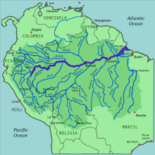
Source of the Amazon River
[5] The Marañón, Mantaro and Apurímac Rivers originate in the high mountain area of the Peruvian Andes at altitudes over 5,000 metres (16,000 ft).
[11][12] The Nupe River has its origin in a system of small lakes near one of the highest peaks of the Huayhuash Range called Siula Grande.
[13] Half a century later, in 1952, two Englishmen, Sebastian Snow and John Brown, identified a small glacial lake called Niñococha, as the source of the Amazon River.
The expedition utilised newly developed satellite imagery, measured by an American cartographic organization to determine the furthest point of flowing water to its meeting the Atlantic Ocean.
Cousteau dispatched a team of German alpinists to summit the 18,000 feet (5,486 m) volcano and during their descent they found melt water dropping into a fissure.
Within this fissure, the water was deep enough to float a small craft presenting the expedition with an opportunity to navigate the highest and furthest origin of the Amazon.
The definition of a "rivers origin" remains subject of debate by communities, organizations, expeditions and adventurers seeking to claim the prize.
A National Geographic Society expedition led by Loren McIntyre identified a small lake 15°30′58″S 71°41′31″W / 15.516°S 71.692°W / -15.516; -71.692, 5,319 metres (17,451 ft)[18] on the northern slope of the Mismi Mountain as the main source.
The real Laguna Bohemia 15°30′43″S 71°42′07″W / 15.512°S 71.702°W / -15.512; -71.702, 5,148 metres (16,890 ft)[20] was later identified by a Czech-Peruvian expedition led by Bohumír Janský as one of the main sources of the Amazon.
In 1996, Polish-born Jacek Palkiewicz and Peruvian Zaniel I. Novoa Goicochea refuted Lake McIntyre and identified a small spring beneath a cliff in the catchment of the Apacheta River near Nevado Choquecorao 15°31′16″S 71°45′40″W / 15.521°S 71.761°W / -15.521; -71.761, 5,182 metres (17,001 ft) [22] as the main source.
In 1999–2000, a Czech scientific team led by Bohumír Janský from the Charles University in Prague, linked to the opinion of Carlos Peñaherrera del Aguila, cooperated with him and named the Carhuasanta River the main source of the Amazon.
Present research confirms their claim of the Carhuasanta River as the main source of the Amazon in the sense of the highest uninterrupted flow rate.
They located the most distant spring in the headwaters of Lake Junin in the Rumi Cruz mountains 10°43′55″S 76°38′53″W / 10.732°S 76.648°W / -10.732; -76.648, at an elevation of 5,220 metres (17,130 ft).
[26] Traditionally, many geographers and explorers have defined a source as the most distant point upstream that provides the largest volume of water to a river.