Sources of the Rhine
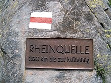
Lake Toma in the Swiss canton of Grisons (Graubünden) is generally regarded as the Source of the River Rhine.
Because the tributary systems of the Rhine differ only slightly in length, discharge and the size of their drainage areas, it is difficult to pinpoint a single source of this major European river.
Apart from the common criterion of the (apparent or real) larger discharge, ongoing cartographic research allows us to determine the headwater with the greatest length, the largest catchment area or (occasionally) the highest source.
The course of the Rein da Tuma, after leaving Lake Toma, is not particularly representative: after about 2 km (1.2 mi), its water is diverted into Curnera reservoir.
This implies that the hydrological main branch starts at the top of the Dischma, far away from greater rivers bearing the name "Rhine".
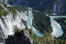
The flow path from the source in Lake Toma through Rein da Tuma measures about 71 km (44 mi) to the confluence of the Vorderrhein and Hinterrhein.
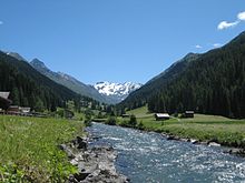
Its spring and upper reaches are located west of the Lukmanier Pass in the municipality of Quinto in the canton of Ticino.
The percentage of precipitation flowing down the river is fairly similar in the valleys of the headwaters of the Rhine, so the size of the catchment area tends to be proportional to the average discharge, and therefore this criterion does not need to be considered separately.