South Dunedin
It is located, as its name suggests, 2.5 kilometres (1.6 mi) to the south of the city centre, on part of a large plain known simply as "The Flat".
The term South Dunedin is often used in a more general sense to refer to any or all of the various suburbs occupying The Flat, including St Kilda, Forbury, Kensington, Musselburgh, and Tahuna.
The flat land which makes up much of Dunedin's heart is enclosed to the south and east by Otago Harbour and to the north and west by a ridge of hills.
At the southern end of central Dunedin, these hills form a ridge that (prior to reclamation) came close to the line of the harbour.
To the east, South Dunedin's natural limit is Otago Harbour, and to the north a ridge of hills also forms a topographical boundary.
As part of an Otago Harbour Board scheme to reclaim land for industrial use, dredges started to pump tailings into the area behind the causeway in the 1940s.
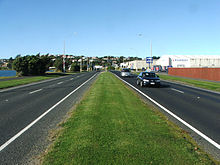
Reclamation continued for many years, and was not officially completed until the opening of Portsmouth Drive, which runs along the route of the 1912 causeway at the harbour edge, in 1978.
Smaller, older shops stretch south along King Edward Street and west along Hillside Road from Cargill's Corner.
These extend into Caversham in the west, and across the reclaimed land which lies between Andersons Bay Road and Portsmouth Drive in the south and east.
This route, which roughly follows the original shoreline, connects with State Highway 1 and Dunedin's one-way street system in the north, and with the suburb of Musselburgh in the south.
A dune barrier was later formed between St Clair and Lawyers Head through the flow of fine sediment from the Clutha River and other smaller catchments.
After the barrier formed, fine sediment accumulated in the waters at the head of the Otago Harbour, causing the sea in that area to became increasingly shallow.
As the city's population expanded during the Otago gold rush, European settlers began reclaiming swampy land in "The Flat."
Consequently, much of South Dunedin was built on land consisting of soft, sandy sediment that was only slightly above the water table (which was up to 17 cm lower than the present day[12]).
The arrival at St Clair of William Henry Valpy (1793–1852) in 1849 led to the first development of permanent roading in the area; Valpy, reputedly the wealthiest man in New Zealand,[14] had a branch dray road built from Dunedin's central settlement to his St. Clair farm which ran along the edge of what is now South Dunedin.
Chinese settlers were notable among early residents in the St Clair area, and largely through their effort the swampy land inland from the beach was drained and converted into market gardens.
The Borough Council has an endowment of 155 acres on the harbour front, which is leased, in small sections, to ratepayers who desire to build in that quarter.
The hall is much used for lectures, dances, and other forms of entertainment, and is centrally situated on the Hillside road, the main business thoroughfare of the borough.
[18] During the 1923 New Zealand Storm, South Dunedin along with Caversham and St Kilda experienced heavy rain and extensive flooding.
[19] During the 1960s and 1970s, further land reclamation occurred between Andersons Bay Road and Portsmouth Drive through the use of dredging spoil excavated from Otago Harbour.
The draft 2025 budget also included allocating NZ$15 million for future medium-term flood alleviation work in South Dunedin.
[29] The industrial heart of South Dunedin is the Hillside Railway Workshops, located immediately to the west of Cargills Corner.
Other notable buildings in South Dunedin include the Mayfair Theatre,[30] close to Cargill's Corner, and the Edgar Sports Centre,[31] at the southeastern extremity of the suburb on Portsmouth Drive.
The Mayfair Theatre has a New Zealand Historic Places Trust (NZHPT) Category II classification [32] The city's former main sports complex, Carisbrook, is located close to the border of South Dunedin in Caversham.
[35] Three of the buildings within the Gasworks complex have NZHPT classifications: the skeleton of the 1879 gasometer,[36] the exhauster and boiler house,[37] and the fitting shop[38] (all Category I).
This company, founded by George Methven, was located for many years in Andersons Bay Road on a site now occupied by a Mitre 10 megastore.
The sports field was relocated to Dunedin North, and the site is now the car park of The Warehouse – all that remains of the original sports complex is a lawn bowls club and the gymnasium, which is also South Dunedin's main war memorial (Hillside Workshops have their own separate memorial by the site's main gate).
The Caledonian was the site of the first human ascent in a hot-air balloon in New Zealand — and first parachute descent — performed by travelling showman Thomas Scott Baldwin on 21 January 1889.