Chicago Loop
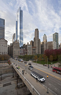
Located at the center of downtown Chicago[3] on the shores of Lake Michigan, it is the second-largest business district in North America after Midtown Manhattan.
The headquarters and regional offices of several global and national businesses, retail establishments, restaurants, hotels, and theaters–as well as many of Chicago's most famous attractions–are located in the Loop.
[4] The neighborhood also hosts Chicago's City Hall, the seat of Cook County, offices of other levels of government, and several foreign consulates.
Since the 1920s, the area bounded by the Chicago River to the west and north, Lake Michigan to the east, and Roosevelt Road (12th Street) to the south is called the Loop.
By the late 19th century, cable car turnarounds and the Union Loop encircled the area, giving the neighborhood its name.
While dominated by offices and public buildings, its residential population boomed during the latter 20th century and first decades of the 21st, partly due to the development of former rail yards (at one time, the area had six major interurban railroad terminals and land was also needed for extensive rail cargo storage and transfer), industrial lands, as well as highrise residences.
When Cook County was incorporated in 1831, the first meeting of its government was held at Fort Dearborn with two representatives from Chicago and one from Naperville.
[11] The Loop, along with the rest of downtown Chicago, is the second largest commercial business district in the United States after New York City's Midtown Manhattan.
[23] Lake View housed 4 percent of Loop employees, the highest percentage of any of Chicago's community areas.
The Loop contains a wealth of outdoor sculpture, including works by Pablo Picasso, Joan Miró, Henry Moore, Marc Chagall, Magdalena Abakanowicz, Alexander Calder, and Jean Dubuffet.
Grant Park is the home of Buckingham Fountain, the Petrillo Music Shell, the Grant Park Symphony (where free concerts can be enjoyed throughout the summer), and Chicago's annual two-week food festival, the Taste of Chicago, where more than 3 million people try foods from over 70 vendors.
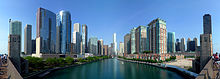
Trips down the Chicago River, including architectural tours, by commercial boat operators, are great favorites with both locals and tourists alike.
Given its proximity to government offices, the center's plaza serves as a kind of town square for celebrations, protests, and other events.
The United States Postal Service operates the Loop Station Post Office at 211 South Clark Street.
[59] The Loop is currently a part of the 4th, 25th, 34th and 42nd wards of the Chicago City Council, which are represented by aldermen Sophia King, Byron Sigcho-Lopez, Bill Conway and Brendan Reilly.
In Metra the Millennium Station, which serves as the Chicago terminal of the Metra Electric District line that goes to University Park, and LaSalle Street Station, which serves as the Chicago terminal of the Rock Island District line bound for Joliet, are in the Loop.
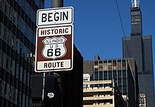
The eastern terminus of U.S. Route 66 (US 66), an iconic highway in the United States first charted in 1926,[76] was located at Jackson Boulevard and Michigan Avenue.
[81] The first parking meters were installed in 1947 and private garages were regulated in 1957; they were banned outright in the Loop in the 1970s in response to federal air-quality standards.
[86] In addition to the government, financial, theatre and shopping districts, there are neighborhoods that are also part of the Loop community area.
The New Eastside is a mixed-use district bordered by Michigan Avenue to the west, the Chicago River to the north, Randolph Street to the south, and Lake Shore Drive to the east.
It encompasses the entire Illinois Center and Lakeshore East[87] is the latest lead-developer of the 1969 Planned Development #70, as well as separate developments like Aon Center, Prudential Plaza, Park Millennium Condominium Building, Hyatt Regency Chicago, and the Fairmont Chicago, Millennium Park.
The New Eastside Association of Residents (NEAR) has been the recognized community representative (Illinois non-profit corporation) since 1991 and is a 501(c)(3) IRS tax-exempt organization.
Wells Drive between Lake Michigan and the Chicago River, excepting Chinatown, is referred to as the South Loop.
Former warehouses and factory lofts have been converted to residential buildings, while new townhouses and highrises have been developed on vacant or underused land.
The South Loop was historically home to vice districts, including the brothels, bars, burlesque theaters, and arcades.
One of the largest homeless shelters in the city, the Pacific Garden Mission, was located at State and Balbo from 1923 to 2007, when it moved to 1458 S. Canal St.
National-Louis University is located in the historic Peoples Gas Building on Michigan Avenue across the street from the Art Institute of Chicago.
[93] Trinity Christian College offers an accelerated teaching certification program at 1550 S. State Street in the South Loop.
Muchin College Prep, a Noble Network of Charter Schools, is also located here, in the heart of Chicago on State Street.
Set aside in the late 19th century, it was originally known as "Lake Park" but was renamed for Civil War general and U.S. President Ulysses Grant.