Ka Lae
The Ka Lae area is registered as a National Historic Landmark District under the name South Point Complex.
The name for the southern tip of the island of Hawaiʻi comes from Ka Lae in the Hawaiian language which means "the point".
The road forks near its end, with one branch leading south to Ka Lae and the other east to Papakolea Beach, known for its green sand.
Ka Lae is the site of one of the earliest Hawaiian settlements, and it has one of the longest archaeological records on the islands.
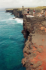
In addition, ancient Hawaiians drilled numerous holes in the rock ledges to use for mooring their canoes.
Tying long ropes to their boats, they would drift out to sea to fish without fear of being carried away by the strong currents.
[15] During World War II, the US Air Force built a landing strip called Morse Field on the point.
[16] In 1961 South Point was on the list of final sites to be considered by NASA to launch crewed rockets to space, but was considered too remote[17] although it was later used to launch sounding rockets for testing of instruments at the Air Force's Maui Space Surveillance Center.
[18] The low latitude of the location also made it (and nearby areas that are as remote) attractive as a site for private rocket launches, but these plans were dropped in the face of high costs and local opposition.
However, Palmyra Atoll contains the southernmost point of all 'incorporated' U.S. territory, according to the doctrine of "incorporation" defined in the Supreme Court's Insular Cases.