Southern Thailand
The western part has highly steep coasts, while on the east side river plains dominate.
The largest artificial lake is the Chiao Lan (Ratchaprapha Dam), occupying 165 km2 (64 sq mi) of Khao Sok National Park in Surat Thani.
[1] Running through the middle of the peninsula are several mountain chains, with the highest elevation at Khao Luang, 1,835 m (6,020 ft), in Nakhon Si Thammarat Province.
The border with Malaysia is formed by the Sankalakhiri range, sometimes sub-divided into the Pattani, Taluban, and Songkhla chain.
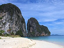
[citation needed] Also well known is the so-called James Bond Island in Phang Nga Bay, featured in the movie The Man with the Golden Gun.
The city Chaiya in Surat Thani Province contains several ruins from Srivijaya times, and was probably a regional capital of the kingdom.
During the rule of King Ramkhamhaeng the Great of Sukhothai, Thai influence first reached Nakhon Si Thammarat.
The deep south belonged to the Malay sultanates of Pattani and Kedah, while the northernmost part of the peninsula was under the control of Bangkok.
During the Thesaphiban reforms at the end of the 19th century, both Nakhon Si Thammarat and Pattani were incorporated into the central state.
The Office of the National Economic and Social Development Council (NESDC) identities Southern Thailand as 14 provinces.
[6] The Thai Meteorological Department (TMD) includes for Southern Thailand (east coast) also the two provinces of Prachuap Khiri Khan and Phetchaburi.
Minority ethnic groups such as Khmer also follow Buddhism, and 10 of the 14 provinces in southern Thailand have Buddhist majorities.
[10] Islam is mostly followed by the Malay people in Southernmost Thailand: Yala, Pattani, Naratiwat and Satun provinces, near Malaysia.
Asian Highway 18 begins in Hat Yai and runs south along the east coast, crossing to Malaysia at Sungai Kolok.
Two smaller branches of the railway run from Thung Song to Trang and Nakhon Si Thammarat and from Hat Yai Junction to Malaysia and Singapore.