South Walls
It is connected to the main body of Hoy, and to the district of North Walls, by a thin neck of land known as the Ayre.
The Norse name of Vágaland, meaning "land of bays" applied to both what is now South Walls and the southern portion of nearby Hoy.
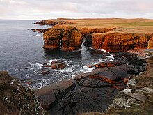
[7][13] South Walls, like most of the Orkney archipelago, is made up of old red sandstone, with the Rousay flagstone group predominating.
[14] It is more or less oval in shape, although there is a small promontory called Cantick Head in the southeast, overlooking Kirk Hope.
[24][15] South Walls features fairly prominently in the Norse period, partly because it was the first landfall when sailing from west Caithness or Sutherland.
Olaf Tryggvasson, King of Norway forced the Earl of Orkney, Sigurd Hloðvisson to be baptised at South Walls.
However, he did so under duress - King Olaf had many valas (Norse shamans) executed by being tied and left on a skerry at ebb.
The tower, together with another on the north side at Crockness on Hoy, was built in 1815 to protect British ships in the bay of Longhope against attack by American and French privateers, during the Napoleonic Wars, while they waited for a Royal Navy escort on their journey to Baltic ports.
[26] Cantick Head is well known for its lighthouse designed and built by David and Thomas Stevenson and first lit in July 1858 and automated in 1991.
[28] South Walls has substantial remains from the Second World War, when Scapa Flow was used as a Royal Navy base.