Most of central and northern California rests on a crustal block (terrane) that is being torn from the North American continent by the passing Pacific plate of oceanic crust.
Movement of the Sierra Madre and Raymond Fault have both lifted the northern Los Angeles Basin while depressing the southern region.
[5] The tall fault block mountains surrounding the Los Angeles region trap moisture and encourage rainfall.
Without these natural barriers mediating the local climate, Los Angeles might be as dry and hot as the Eastern deserts of California.
On the other hand, it has been noted that the encircling mountains tend to trap smog, causing it to accumulate in the populated region instead of moving out to sea or further inland.
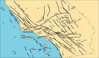
Simplified fault map of southern California
The faults of Southern California viewed to the southeast, as modeled by the
Southern California Earthquake Center
. Highlighted in purple are the San Andreas Fault (left) and Santa Monica Bay complex (right). The foreground is in the
Santa Barbara Channel
, the east-trending zone marks the
Transverse Range
. Faults in the upper left are part of the Eastern California Shear Zone, connecting northward with the
Walker Lane
region. Faults extend deeper than shown.
Cumulative energy released by all earthquakes in Southern California from 1932 through July 2014. Highest energy in red, the lowest energy in dark blue. Data from the
Southern California Earthquake Center
. (Click on an icon for a larger image.)
"Map of faults in southern California," By Natural Hazards Mission Area Photographer, Kate Scharer, USGS Sources/Usage, Public Domain Accessed 10-20-2024