Southern Netherlands
The Southern Netherlands comprised most of modern-day Belgium and Luxembourg, small parts of the modern Netherlands and Germany (the Upper Guelders region, as well as the Bitburg area in Germany, then part of Luxembourg), in addition to (until 1678) most of the present Nord-Pas-de-Calais region, and Longwy area in northern France.
The (southern) Upper Guelders region consisted of what is now divided between Germany and the modern Dutch Province of Limburg (in 1713 largely ceded to Prussia).
Following the war, Austria's loss of the territories was confirmed, and they were joined with the northern Netherlands as a single kingdom under the House of Orange at the 1815 Congress of Vienna.
In the early 17th century, there was a flourishing court at Brussels, which was under the government of King Philip III's half-sister Archduchess Isabella and her husband, Archduke Albert of Austria.
The area had, in fact, been given to Austria largely at British and Dutch insistence, as these powers feared potential French domination of the region.
In 1784, its ruler, Emperor Joseph II, took up the long-standing grudge of Antwerp, whose once-flourishing trade was destroyed by the permanent closing of the Scheldt, and he demanded for the Dutch Republic to open the river to navigation.
Though Joseph secured in the 1785 Treaty of Fontainebleau that the territory's rulers would be compensated by the Dutch Republic for the continued closing the Scheldt, this failed to gain him much popularity.
Only a minority of the population – mostly the local Jacobins and other members of "Societies of Friends of Liberty and Equality" in urban areas – supported the annexation.
In 1797, nearly 8000 priests refused to swear the newly introduced Oath of Hatred of Kings ("serment de haine à la royauté"), and went into hiding to escape arrest and deportation.
The situation, particularly in the religious field, eased with the rise to power of Bonaparte in 1799, but soon, the intensification of conscription, the police state and the Continental System, which brought ruin to Ostend and Antwerp, reignited opposition to French rule.
[1] During that period Belgium was divided into nine départements: Deux-Nèthes, Dyle, Escaut, Forêts, Jemmape, Lys, Meuse-Inférieure, Ourthe and Sambre-et-Meuse.

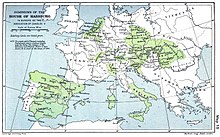
Note that 'Upper Guelders' ( south of the main area of Guelders in Netherlands, and east of the Duchy of Brabant, in light yellow) was mistakenly left white on this map!