Spinalonga
Spinalonga (Greek: Σπιναλόγκα) is an island in the Gulf of Elounda, north-eastern Crete, in the municipality of Agios Nikolaos, Lasithi, next to the town of Plaka in the area of Kalydon.
To the south a narrow strip of water separates it from Kolokitha island, while the east is open to the Sea of Crete.
It is only 85,000 square meters in size,[4] and largely rocky, with steep cliffs at the northern side of the island.
[1] The Venetians began to construct salt-pans in the shallow and salty waters of the gulf in the mid fifteenth century.
This, in combination with the emergent Turkish threat, particularly after the Fall of Constantinople in 1453, and the continuous pirate raids, forced the Venetians to fortify the island.
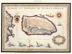
[citation needed] The Provveditore generale Jacob Foscarini suggested fortifications for Spinalonga, and a group of engineers were sent to the island in 1574 to survey the topography.
He created blockhouses at the highest points of the northern and southern side of the island, as well as a fortification ring along the coast that countered any hostile disembarkation.
In 1579, the Provveditore generale di Candia Luca Michiel, laid the foundation stone of the fortifications, built over the ruins of an acropolis.
The new Venetian firepower had longer range, rendering Spinalonga one of the most important sea forts in the Mediterranean basin.
[1] Spinalonga, along with Gramvousa and Souda, remained in Venetian hands after the rest of Crete fell to the Ottomans in the Cretan War (1645–1669).
These three forts defended Venetian trade routes and were also useful bases in the event of a new Venetian-Turkish war for Crete.
[5] Iakovos Jiritas built a church in 1709 on the island, called Agios Paneteleimon after Saint Panteleimon.
The majority of the inhabitants abandoned the island after the Ottoman defeat in 1898, though a small number of traffickers remained until 1903.
In this regard the Cretan government was influenced by the work of Edvard Ehlers, a Danish dermatologist and advocate for seclusion theory.
Leprosy was associated with extreme stigma at the time, and families of those who were sent to Spinalonga often avoided mentioning their connection to the place.
[2] The first arrivals settled in the lowlands of the island and destroyed the Muslim homes (from the Ottoman era), using the materials for their own construction.
A graveyard was maintained for the residents, and a yellow flag flew from the highest point to warn travellers of the presence of leprosy.
[11] They generally lived alone in their own homes and were reliant on the collection of rainwater, and shipments of water and food from the mainland.
[1] The inhabitants practiced folk medicine in an attempt to alleviate their symptoms, as there was no hospital or support available for them initially.
[11] In 1938 it gained permission from the Greek government to demolish a section of the medieval fortifications and build a path around the perimeter of the island, which was accessible for handicapped lepers.
They would congregate on the sunny, wind protected eastern part of the island to play backgammon and checkers.
[13] World War II had a deleterious effect on conditions on the island, as Greece came under occupation by the axis powers.
[1] New treatments for leprosy were offered on Spinalonga from 1948, which led to a weakening of the isolation rules including short-term discharge permits.
The fact that it depicted the actual lepers was considered controversial, as it went against the then-prevailing view of Greece in film as "a sunny country with handsome shepherds".
A British expert visited and wrote a report criticising the Greek state for its failure to care for the residents.
[5] The island was left empty for decades after the departure of Katsouloyiannakis, and suffered from looting during the Greek junta period (1967-1974).
Access to it was banned on the grounds of a fictional infection risk; the "fairytale" restriction was designed to prevent looters.
[2] By 1969 he was renting a home in Plaka and visiting the island daily for research, crossing over in an inflatable boat.
[20][2] After a problem with tourists desecrating graves, the bones of the deceased were removed and placed in a ossuary next to the cemetery with new plaques in 2013.
Tourist boats depart regularly from all three towns, and the island receives hundreds of thousands of visitors per year.