Spiti
Spiti (pronounced as piti in Bhoti language) is a high-altitude region of the Himalayas, located in the north-eastern part of the northern Indian state of Himachal Pradesh.
Spiti is bordered on the east by Tibet, on the north by Ladakh, on the west and southwest by Lahaul, on the south by Kullu, and on the southeast by Kinnaur.
Spiti is a popular destination for photography, snow leopard spotting, and adventure tourism of various kinds, including winter sports.
The name "Spiti" is derived from "Piti", which means "the middle land" as the valley is surrounded on all sides by mountain ranges that separate it from former empires.
Based in Spiti valley, the Thakur gangs raided the upper parts of Kullu, before the Sen kings established their rule.
In 95 BC, invasions began which were unsuccessful even until 846 A.D.[citation needed] There is evidence of very early human habitation in the Spiti valley, primarily through its rich heritage of pre-Buddhist rock art.
Spiti's rock art is thought to have been produced over a wide period of time, with the earliest examples dating back nearly 3,000 years.
[4] There is some evidence to show that Spiti was a part of the western Tibetan kingdom of Zhang Zhung until the mid-7th century CE.
[6] In the 10th century, Spiti was part of the kingdom of Ngari Khorsum, established by Kyide Nyimagon of the Tibetan royal lineage.
Under the Treaty of Amritsar (1846), Spiti alongside Lahaul was split off from the erstwhile kingdom of Ladakh, and came under direct British administration.
In 1873 the Nono of Kyuling village, near Kaza, was delegated the responsibility of collecting revenue from Spiti for the British, and was also given some judicial powers.
[11] Lahaul and Spiti district was merged with Himachal Pradesh on 1 November 1966 on enactment of the Punjab Reorganisation Act.
The annexation of Tibet by the People's Republic of China in 1951 turned Spiti into a sensitive region for the Indian government.
[10] The Spiti valley is located between the Kunzum range in the NW to Khab on the Sutlej river in Kinnaur in the SE.
[9]: 27 The Taktsi tributary flows out of the Nogpo-Topko glacier, near Kunzum La 150 km (93 mi), the Spiti ends in the Satluj at Khab.
[12] The Moravian geologist Ferdinand Stoliczka discovered a major geological formation near Mud village in Spiti in the 1860s.
[17] Climate change is threatening the tradition of Gaddi shepherds' annual migrations to Spiti with their herds of goat and sheep.
It is degrading the quality of the pastures, and the ice bridges that Gaddis with their flocks could earlier use to cross rivers while bypassing villages are now disappearing.
[18] Scientific studies back up the ground-level observations that climate change due to global warming has been adversely affecting the environment of the Spiti valley.
The alpine pastures on the high plateaus of Spiti are home to a variety of small bushes and grasses including Rosa sericea, Hipopheae, and Lonicera among others.
[21] In terms of wildlife, among other species, the Spiti region is home to the Himalayan Ibex (Capra sibirica hemalayanus), the snow leopard (Panthera uncia),[22] the red fox (Vulpes vulpes), pika (Ochotana roylei), Himalayan wolf (Canis lupus laniger), and weasels (Mustela spp).
This is because the road runs parallel to the Sutlej river initially, climbing steadily to 2,550 m (8,370 ft) at the confluence of the Spiti and Satluj near Khab.
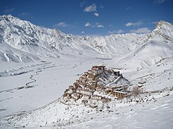
[30] The local people of Spiti follow Tibetan Buddhism,[31] and its culture is similar to those of its neighbouring regions such as Tibet, Ladakh,[32] and the Hangrang valley of Kinnaur district.
[35] After Taklung Setrung Rinpoche, the head of the Nyingma sect and a noted scholar of the Tibetan Tantric school died on 24 December 2015, a search was started for his successor.
In November 2022, the Nyingma sect located a boy in Rangrik village, Spiti who they believed to be the reincarnation of the late Rinpoche.
[38] Traditionally, in Spiti, the society consisted of a hierarchy, with the Nonos (local aristocracy) at the top, the Chhazang (agriculturalists, practitioners of Tibetan medicine, and astrologers) in the middle, and the 'pyi-pa' (the separate endogamous groups of the 'Zo' blacksmiths and the 'Beda' musicians) at the bottom.
The alcoholic beverages chhaang and arak are locally prepared and very popular, both in festivals and on various occasions like birth, marriage, the celebration of some success, and death.
Cash-crop agriculture (of the green pea and apples), employment in state departments and development projects, and tourism are the main sources of income in the Spiti valley.
An administrator in 1871 reported that yaks were used for ploughing and the main crops were a fine hexagonal wheat, peas, mustard and two kinds of barley.
[44] Road access has been noted as being vital to Spiti's cash crop economy, as the harvest is almost entirely sold in distant markets in the north Indian plains.