Sri Ganganagar
Sri Ganganagar is the northernmost city of the Indian state of Rajasthan, near the international border of India and Pakistan.
[4] Sri Ganganagar is one of the first well-planned modern cities of India, it is said to be influenced by the town planning of Paris.
It is divided into residential blocks and a commercial area which includes a Dhan Mandi (agricultural marketplace).
He informed the Maharaja about his successful invasion of the area when he reached the northern part and thereafter died, giving name to the city Hindumalkot.
To resolve this issue, Maharaja Ganga Singh obtained the services of AWE Standley, an engineer, who demonstrated the feasibility of the western area of the Bikaner State being irrigated by the waters of the Sutlej.
The plan of the Sutlej Valley Project was drawn by the chief engineer of Punjab, RG Kennedy, according to which the vast area of erstwhile Bikaner State could be brought under irrigation.
With the intervention of the Viceroy of India, Lord Curzon in 1906, a Tripartite Conference was held and an agreement was reached on 4 September 1920.
The district can be classified into five geographical regions: According to the 2011 census Sri Ganganagar city and outgrowths had a population of 237,780.
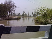
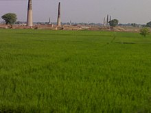
It carries the excess waters of Punjab and Himachal Pradesh to the region, making Ganganagar a district known as the "food basket of Rajasthan".
Fresh Kinnow Waxing, Kanda Edible Oil Unit, Ruchi Soya Industries etc.
The famous temples in Sri Ganganagar include Sri Ganganagar is well connected with road and is linked directly to Delhi, Jaipur, Ludhiana, Chandigarh, Sikar, Karnal, Haridwar, Bathinda, Ambala, Jodhpur and many other cities.
The city is directly connected to Delhi, Jaipur, Kota, Bikaner, Haridwar, Hanumangarh, Jodhpur, Ambala, Sikar, Bathinda, Firozpur, Fazilka, Howrah, Trivandrum, Nanded, Ahmedabad, Pune, Roorkee, Kanpur, Bangalore and some other cities via train.