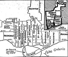
St. David (provincial electoral district)
It covered a section of the eastern city of Toronto east of Sherbourne Street and west of the Don River.
The riding lasted until 1987 when it was merged with the neighbouring St. George to create a larger district called St. George—St.
It then went west along the right-of-way until it reached the Vale of Avoca ravine now occupied by David Balfour Park.
It followed ravine north through the Mount Pleasant Cemetery until it reached a point where Yonge Street was crossed by the former Belt Line Railway right-of-way.
It then turned east following the original Belt Line right-of-way which curved south to join up with the path of Mud Creek.
The river was followed to a point just north of the Bloor Viaduct where the old Toronto city limits was met.