St. George, Staten Island
By 1765, part of the Dorlant tract was owned by John Wandel, a molasses distiller who operated a plant at the Kill Van Kull near Richmond Terrace and Westervelt Avenue, taking advantage of the Jersey Street brook.
[19][12] Tompkins also incorporated the Richmond Turnpike Company to build present-day Victory Boulevard in 1816, started operating a ferry to Manhattan in 1817, and laid out the adjacent village of Tompkinsville for development between 1819 and 1821.
[12][21] Tompkins's property within present-day St. George was sold in April 1834 to Manhattan developer Thomas E. Davis, who continued to buy land through the following year.
[22][23] Davis came to own all the land on Staten Island's northeastern shore, bounded to the south by Victory Boulevard, to the west by Sailors' Snug Harbor, and to the north and east by the waterfront.
Other streets were named after people or places that were associated with the development of the area, including Tompkins, Davis, or the Stuyvesant family (who were early investors).
[33] Additionally, new houses such as Italianate villas were built, while existing Richmond Terrace mansions were expanded or received new annexes and gardens.
[33] Several greenhouses were also built in the neighborhood, particularly on the land of the merchant John C. Green, part of whose estate is now the site of Curtis High School.
Initially, the local economy suffered due to cessation of trade with the Southern United States, but because of the Union Army's demand for material, many entrepreneurs and workers moved to New York City, including to Staten Island's North Shore.
[3][40][41][42] St. George was selected for the terminal due to the site being the closest point from Staten Island to Manhattan, approximately a 5-mile (8.0 km) distance.
At this time immigrant groups settled in New Brighton in greater numbers; Italians and African-Americans along the Kill Van Kull, and Jewish communities on the eastern boundary of the village near St. George and Tompkinsville.
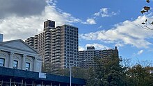
[53][54] In the years after unification, the North Shore became quickly urbanized, and the political and economic center of Staten Island shifted to the region.
[55] Several government buildings were also built in the area because of Cromwell's decision to make St. George the primary civic center for Staten Island.
[59] Other city services were also brought to Staten Island following unification, such as schools, emergency facilities, new roads, and utilities including an underground water supply.
[61] Development of buildings in St. George increased following World War I, with one person stating that Stuyvesant Place "look[ed] like a ravine" due to the pace of new residential construction.
[69] As early as 1919, "St. George" was used to describe the northeastern waterfront of Staten island as well as the hills immediately adjacent to the ferry terminal.
[55] The opening of the Verrazzano-Narrows Bridge in 1964 created a connection between Staten Island and the rest of New York City that did not require passing through St. George, and led to the development of neighborhoods further inland.
[3] In 1994, the New York City Landmarks Preservation Commission designated the St. George Historic District, which includes 78 houses and St. Peter's Church.
[77] By the late 1990s and early 2000s, younger families were starting to move to St. George, since housing in the neighborhood was cheaper compared to in the rest of the city.
[86] In 2007, several media reports noted that artists and musicians were moving to Staten Island's North Shore so they could be near Manhattan but afford more space to live and work.
[95] For census purposes, the New York City government classifies St. George as part of a larger neighborhood tabulation area called West New Brighton-New Brighton-St.
[2] In 2018, an estimated 21% of St. George and the North Shore residents lived in poverty, compared to 17% in all of Staten Island and 20% in all of New York City.
Based on this calculation, as of 2018[update], St. George and the North Shore are considered high-income relative to the rest of the city and not gentrifying.
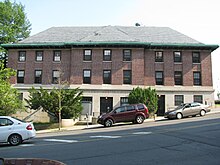
The Staten Island Borough Hall, at 2–10 Richmond Terrace, was built in 1906 and was designed by Carrère and Hastings in the French Renaissance style.
[57][115][116] A structure for the New York City Department of Health and Mental Hygiene, designed in the Art Deco style, is located on Hamilton Avenue.
[28][29] The Fort Hill area comprises the remains of the streets and homes where the descendants of the Tompkins, Westervelt, and Low families lived.
The residential Fort Hill area includes many examples of Victorian, Tudor, Shingle style, and Art Deco architecture, in addition to one house modeled after a Spanish castle.
[84][113] The memorial includes two white marble wing sculptures, each standing 30 feet (9.1 m) high, which represent large postcards to loved ones.
[99]: 14 The concentration of fine particulate matter, the deadliest type of air pollutant, in St. George and the North Shore is 0.0071 milligrams per cubic metre (7.1×10⁻⁹ oz/cu ft), less than the city average.
[99]: 6 The percentage of St. George and the North Shore students excelling in math rose from 49% in 2000 to 65% in 2011, though reading achievement declined from 55% to 51% during the same time period.
[155] St. George and the North Shore's rate of elementary school student absenteeism is slightly higher than the rest of New York City.