St Helens, Isle of Wight
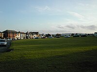
St Helens is a village and civil parish[2] located on the eastern side of the Isle of Wight.
It is linked to other parts of the island by Southern Vectis bus route 8 serving Ryde, Bembridge, Sandown and Newport including intermediate villages.
[4] The origin of St Helens seems to revolve around the Cluniac Priory and the monastic church, built circa 1080.
It is believed that Admiral Lord Nelson's last view of England was of the St Helens seamark - HMS Victory had anchored nearby to collect drinking water, before setting sail for Cádiz and participation in the Battle of Trafalgar.
[6] St Helens is located to the east of the Isle of Wight on high ground to the north of Bembridge giving it views over the harbour.
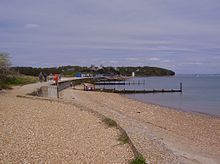
The village is located on the coast, with St Helens Duver nearby at the mouth of the harbour.
During the summer season the beach is litter picked, with large amounts of seaweed removed and given to local farmers for composting.
[8] The Eastern Yar, from its source at Niton to the south of the island, runs through the village en route to the Solent.
The present church is a stone structure with brick dressings, and consists of an aisleless nave, with transepts, a chancel and west tower with one bell.
Priory Bay Hotel is now the subject of a major planning application as announced in the Isle of Wight County Press.
"FORMERLY one of the Island’s top hotels, Priory Bay could be back in businesses following a multi-million pound makeover.