St Helens, Merseyside
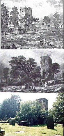
[20][21] Eccleston in St Helens appears to derive its name from either the Latin ecclesia or the Brittonic eglwys, both meaning "church", suggesting a common link to a place of worship although none is known in that township until the 19th century.
The Earl of Derby's lands encompassed a region from Liverpool to Manchester, and to the north beyond Lancaster and were primarily turned to meeting the pastoral needs of the people.
Historically this would have fallen within the berewick of Hardshaw, within the greater township of Windle (making up the southern border)[29][31] abutting onto the open farmland of Parr to the east, and Sutton and Eccleston to the south and west respectively.
[10] The chapel was described as being at the crux of the four townships of Eccleston, Parr, Sutton and Windle,[10] and lay on the intersecting roads that criss-crossed the area and linked Lancashire towns such as Liverpool, Ormskirk, Lathom[10] and the Cheshire region south of the River Mersey.
[24] The chapel also sat directly between the port town of Liverpool, and the landlocked Manchester townships that would become important in the development of the greater area of both St Helens and Wigan.
The strong link to Roman Catholicism in the area was maintained throughout this period by the eventual Lords of Sutton Manor, the De Holland family, starting in 1321.
[23] Thomas Holland, a local Jesuit priest, was arrested and tried for high treason in October 1642 as "taking orders by authority of the see of Rome and returning to England".
In 1602, two women were sent to Lancaster for trial, while a decade later Isobel Roby was submitted to Sir Thomas Gerard, accused of upsetting the ship upon which James VI and I's Queen Consort Anne of Denmark was arriving.
[10] The discovery of winnable coal seams is mentioned in 1556, referred to as "Beds of cinders or coke ... have been discovered three feet thick"[23] during the digging of a clay pit[31] and is commonly attributed to the Eltonhead family (Elton Head Road, the modern B5204, shares the name of the family) whilst reference to the significant distribution of "potsherds"[23] during excavation suggests that some light industry had been underway for some time before (perhaps as far back as the 13th century) and the clay and pottery industries lasted in the area through to the early 20th century.
[22] Even so, Farrer also notes that several old quarries and shafts still existed within the area while also making reference to a "brewery at Portico, and a pottery near Prescot, while glass, watchmakers' tools, and mineral waters are also manufactured".
[22] Two hundred years earlier, Farrer may well have seen a different sight: St Helens was scarred and pitted by shallow mining operations, often quickly abandoned, left to flood and exceedingly prone to collapse.
The dependence of St Helens on its transport links is evident from claims made to Parliament in 1746 for maintenance and extension of the turnpike road after local flooding had damaged it.
It was originally proposed merely to make the Sankey Brook navigable, but the eventual outcome was a complete man-made canal linking St Helens to the River Mersey and the city of Liverpool.
The Sankey Canal was opened in 1757, and extended in 1775, to transport coal from the pits in Ravenhead, Haydock and Parr to Liverpool, and for raw materials to be shipped to St Helens.
[31] Land exchanged hands in St Helens rapidly, as established families moved out of the growing towns filled with the working classes to more gentrified and less industrially developed places.
[31][26] This allowed copper ore carried from the Parys Mountain mine in Amlwch in Anglesey, North Wales to arrive in the St Helens region via the Mersey directly at the point where coal was being excavated to fire the forges of industry.
An over-reliance on shipping to the USA during the American War of Independence (1775–1783) ruined many people, and led to the permanent loss of several smaller industries.
A new Tesco Extra store opened in October 2011 on the outskirts of the town centre to replace the existing Chalon Way superstore, which has now been taken over by new retail Home & Leisure outlet, The Range.
The scheme's success led to it being expanded to other identified areas in need of redevelopment including Four Acre (in Clock Face), Thatto Heath and the North of the Town Centre.
The sundial over the door of the meeting house is dated 1753, while a curiosity in the garden is a huge glacial boulder, said to have been deposited from the Lake District following the last ice age.
It was built between 1929 and 1934 and was opened by King George V. It was intended to take pressure away from the A58, a major road running from Prescot (M57) through St Helens to the A1(M) at Wetherby, West Yorkshire.
A major development in communication was the opening of the dual-carriageway St Helens Linkway (classified as part of the A570) in 1994, which linked the town centre directly with the M62 (at Rainhill).
[79][80] In 2010, St Helens was proclaimed "UK's most car-friendly town" measured on variables such as "petrol prices, parking costs and the number of speed cameras in an assessment carried out by Virgin Money Car Insurance" in research conducted by The Independent newspaper.
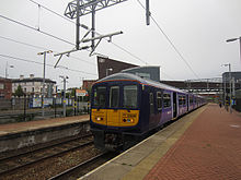
After privatisation in 1986, the town was served by several locally branded operations under the umbrella of Merseyside Transport Limited (MTL), in which Merseytravel retained shares until 1993.
Several smaller operators run specific routes within the town area, such as Cumfybus, Hattons, HTL Buses, Red Kite[82] Stagecoach Merseyside & South Lancashire and local municipal bus companies.
There were also three zero-fare services operated by battery-electric minibuses in and around the town centre, ferrying passengers to nearby retail parks such as Ravenhead, which were provided on behalf of Merseytravel by Selwyns Travel.
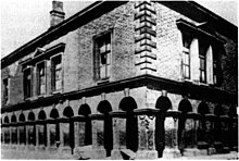
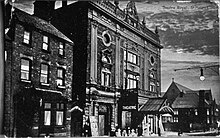
St Helens, in Hardshaw of Windle, constructed its original Town Hall in 1839 that served as a legal court, meeting house, and administrative centre.
[78] By 2006, the otherwise transient gypsy and traveller community have overtaken that number and are now considered to "make up the largest identifiable ethnic minority group in St Helens".
Parr has Gaskell Park in addition to the reclaimed open space known as The Duckeries (or Ashtons Green), and shares a boundary with boggy heathland known as "The Moss" or "Colliers Moss" (traditionally associated with Bold and its power station), and the area known as the "Flash" (remnants of the canal tributary system and fishing ponds) with a nature walk along part of the 7 mi (11 km) route that makes up the Sankey Valley Country Park (part of the Trans Pennine trail).
[110] St Helens Town FC is an amateur English football club, currently playing in the first division of the Liverpool County Premier League.