Llano Estacado
The Llano Estacado (Spanish: [ˈʝano estaˈkaðo]), sometimes translated into English as the Staked Plains,[2] is a region in the Southwestern United States that encompasses parts of eastern New Mexico and northwestern Texas.
Leatherwood writes that Francisco Coronado and other European explorers described the Mescalero Ridge on the western boundary as resembling "palisades, ramparts, or stockades" of a fort, but does not present the original Spanish.
[2] In Beyond the Mississippi (1867), Albert D. Richardson, who traversed the region from east to west in October 1859, wrote that "the ancient Mexicans marked a route with stakes over this vast desert, and hence its name.
"[5] Other sources refer to "stakes" used to mark routes on the featureless plain, often meaning piles of stone, bone, and cow dung.
[18] Robert Neighbors and Rip Ford, guided by Buffalo Hump, blazed the "upper route" trail from San Antonio to El Paso in 1849 for emigrants during the California Gold Rush, "... travelling across an elevated plateau almost covered by rock ..."[17]: 114 and 121 After his 1852 expedition to explore the headwaters of the Red and Colorado Rivers, General Randolph Marcy wrote: "[not] a tree, shrub, or any other herbage to intercept the vision ... the almost total absence of water causes all animals to shun it: even the Indians do not venture to cross it except at two or three places.
[19] During the 1854 Marcy-Neighbors expedition, Dr. George Getz Shumard noted, "Beyond the mountain appeared a line of high bluffs (the Llano Estacado) which in the distance looked like clouds floating upon the horizon.
Several small- to medium-sized towns do exist, however, including Andrews, Hereford, Plainview, Levelland, Big Spring, and Lamesa, Texas, and Hobbs, Clovis, and Portales, New Mexico.
The Ogallala Formation is a wedge of sediments built up eastward of the Rocky Mountains as they were uplifted in the Miocene, with the consequent alluvial fans referred to as the "Gangplank".
But after a High Plains thunderstorm, water quickly fills the ponds, only later soaking into the underlying porous sandstones just below the surface to add to the groundwater in the Ogallala aquifer.
[4]: 357 The Pecos and Canadian rivers have eroded the Llano Estacado region down to the Triassic and Permian redbeds resulting in a distinctive color contrast besides separating it from source rocks in the Rocky Mountains.
[citation needed] Overuse of the aquifer in the past has persuaded some farmers to return to dryland crops, leading to less rainwater reaching the playas.
[27] "Cotton, grain sorghum, corn, wheat, peanuts, sunflowers, grapes, vegetables, and cattle produced in the region literally go around the world.
"[28] One of the largest economic drivers on the Llano Estacado is in energy production, with the region experiencing significant activity for producing oil and natural gas associated with the Permian Basin.
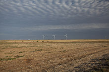
Additionally, solar and wind farms have proliferated on the Llano Estacado due to the region's dry and windy climate making it a favorable location for the production of renewable energy.